IMAGES TAKEN NEAR TO
Haywood Road, NOTTINGHAM, NG3 6AF
Introduction
This page details the photographs taken nearby to Haywood Road, NG3 6AF by members of the Geograph project.
The Geograph project started in 2005 with the aim of publishing, organising and preserving representative images for every square kilometre of Great Britain, Ireland and the Isle of Man.

There are currently over 7.5m images from over14,400 individuals and you can help contribute to the project by visiting https://www.geograph.org.uk
Image Map
Images are licensed for reuse under creativecommons.org/licenses/by-sa/2.0
Notes
- Clicking on the map will re-center to the selected point.
- The higher the marker number, the further away the image location is from the centre of the postcode.
Image Listing (27 Images Found)
Images are licensed for reuse under creativecommons.org/licenses/by-sa/2.0
Image
Details
Distance
1
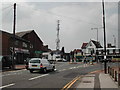
Communications Mast
At the junction of Westdale Lane and Woodborough Road
Image: © Tom Courtney
Taken: 18 Aug 2005
0.08 miles
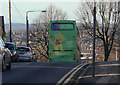
2
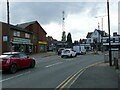
Communications Mast
Recreating this 'First' for the square http://www.geograph.org.uk/photo/39364
Image: © Alan Murray-Rust
Taken: 27 May 2021
0.08 miles
3

Mapperley Plains
On top of the ridge (spot height 127m/416ft), looking towards the corner of Westdale Lane and the shops beyond. The land slopes down sharply either side of Plains Road, to Gedling and the Trent Valley (20m/65ft) to the south east and to Daybrook, Woodthorpe and Arnold to the north east.
Image: © John Sutton
Taken: 23 Jun 2014
0.09 miles
4
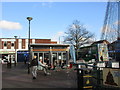
Alfresco Caffe
At the centre of the shopping area on Plains Road.
Image: © Jonathan Thacker
Taken: 7 Dec 2015
0.10 miles
5
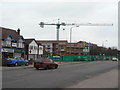
New homes for the elderly
Development on Mapperley Plains at the corner of Hazel Grove.
Image: © Alan Murray-Rust
Taken: 1 Feb 2009
0.10 miles
6
Over the edge
The top of Breck Hill Road is one of the steepest sections of the Nottingham City Transport route network, with a gradient of around 1 in 8. As it is on a north facing slope, it is usually one of the first to suffer when there is snowfall.
Image: © Alan Murray-Rust
Taken: 18 Nov 2008
0.14 miles
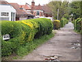
7
Gretton Road
The land drops steeply away at the end of the street.
Image: © Jonathan Thacker
Taken: 7 Dec 2015
0.17 miles
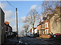
8
Nottingham - NG3 (Mapperley)
The view along Birkland Avenue, an unadopted cul-de-sac off Beech Avenue.
Image: © David Hallam-Jones
Taken: 11 May 2012
0.17 miles
9
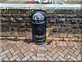
Boundary Marker, Mapperley
At the top end of Woodthorpe Drive where it meets Woodborough Road. On the wall surrounding the monument.
Listed Grade II see https://historicengland.org.uk/listing/the-list/list-entry/1270396
Inscription: 1877 // Borough of Nottingham // Boundary
Milestone Society National ID: NT_NOT16pb
Image: © Nick Osmond
Taken: 30 Sep 2021
0.17 miles
10
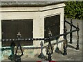
Mapperley War Memorial ? detail
Commemorative bronze plaques and ornate cast iron railings. Listed Grade II.
Image: © Alan Murray-Rust
Taken: 27 May 2021
0.17 miles