IMAGES TAKEN NEAR TO
Clementine Drive, NOTTINGHAM, NG3 5UX
Introduction
This page details the photographs taken nearby to Clementine Drive, NG3 5UX by members of the Geograph project.
The Geograph project started in 2005 with the aim of publishing, organising and preserving representative images for every square kilometre of Great Britain, Ireland and the Isle of Man.

There are currently over 7.5m images from over14,400 individuals and you can help contribute to the project by visiting https://www.geograph.org.uk
Image Map
Images are licensed for reuse under creativecommons.org/licenses/by-sa/2.0
Notes
- Clicking on the map will re-center to the selected point.
- The higher the marker number, the further away the image location is from the centre of the postcode.
Image Listing (36 Images Found)
Images are licensed for reuse under creativecommons.org/licenses/by-sa/2.0
Image
Details
Distance
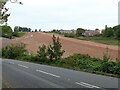
1
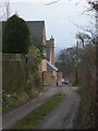
Lane to Chase Farm
Modern housing off Mapperley Plains is now intruding on the scene.
Image: © Alan Murray-Rust
Taken: 1 Feb 2009
0.05 miles
2
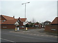
Chartwell Grove
Modern housing development off Mapperley Plains. This area was previously the landsale wharf for Gedling Colliery.
Image: © Alan Murray-Rust
Taken: 1 Feb 2009
0.06 miles
3
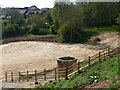
Ramp to Mapperley Plains
Ongoing construction of the Gedling Access Road.
Image: © Alan Murray-Rust
Taken: 30 May 2021
0.08 miles
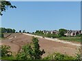
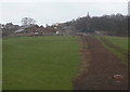
4
Chase Farm
This has been a green oasis between the residential area of Mapperley and the former Gedling Colliery, the spoil heap of which dominates the skyline. This area is now earmarked for a major residential development of around 3500 homes, with corresponding commercial developments.
Image: © Alan Murray-Rust
Taken: 1 Feb 2009
0.08 miles
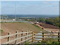
5
The new Gedling Access Road under construction
A very substantial embankment has been constructed to bring the road up to Mapperley Plains.
Image: © Alan Murray-Rust
Taken: 27 Sep 2020
0.09 miles
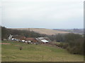
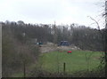
6
Chase Farm
Seen from Arnold Lane. The dug strip appears to be drainage from new housing development behind the farm.
Image: © Alan Murray-Rust
Taken: 1 Feb 2009
0.09 miles
7
Farmland near Chase Farm
This has been a green oasis between the residential area of Mapperley and the former Gedling Colliery, the spoil heap of which dominates the skyline. This area is now earmarked for a major residential development of around 3500 homes, with corresponding commercial developments.
Image: © Alan Murray-Rust
Taken: 1 Feb 2009
0.10 miles
8
A new view across the Trent Valley
Made possible as a result of the construction of Colliery Way. The spire of All Hallows Church, Gedling is a prominent local landmark.
Image: © Alan Murray-Rust
Taken: 29 Apr 2022
0.10 miles
9
Bottom Pepperpot, Mapperley
One of the ventilation shafts of the former Gedling Tunnel on the old Great Northern Railway line from Nottingham to Derby, known locally as pepperpots. The shaft has been retained as the tunnel is an important bat roost.
Image: © Alan Murray-Rust
Taken: 29 Apr 2022
0.10 miles
10

Red and blue
Modern housing alongside Gedling Country Park.
Image: © Alan Murray-Rust
Taken: 26 Apr 2021
0.11 miles