IMAGES TAKEN NEAR TO
Copplestone Drive, NOTTINGHAM, NG3 5SH
Introduction
This page details the photographs taken nearby to Copplestone Drive, NG3 5SH by members of the Geograph project.
The Geograph project started in 2005 with the aim of publishing, organising and preserving representative images for every square kilometre of Great Britain, Ireland and the Isle of Man.

There are currently over 7.5m images from over14,400 individuals and you can help contribute to the project by visiting https://www.geograph.org.uk
Image Map
Images are licensed for reuse under creativecommons.org/licenses/by-sa/2.0
Notes
- Clicking on the map will re-center to the selected point.
- The higher the marker number, the further away the image location is from the centre of the postcode.
Image Listing (18 Images Found)
Images are licensed for reuse under creativecommons.org/licenses/by-sa/2.0
Image
Details
Distance
1
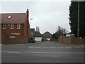
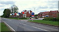
Orchard Park
Modern housing development off Mapperley Plains, replacing orchard and gardens.
Image: © Alan Murray-Rust
Taken: 1 Feb 2009
0.14 miles
2

Red and blue
Modern housing alongside Gedling Country Park.
Image: © Alan Murray-Rust
Taken: 26 Apr 2021
0.15 miles
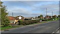
3
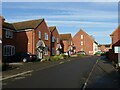
Axmouth Drive, Mapperley Plains
Part of the most recent, 21st century, housing development along Spring Lane.
Image: © Alan Murray-Rust
Taken: 22 Nov 2020
0.15 miles
4
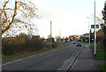
Spring Lane
Looking east from the junction with Mapperley Plains.
Image: © Alan Murray-Rust
Taken: 18 Jan 2009
0.16 miles
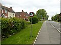
5
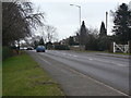
Mapperley Plains
A ridge route leading from Nottingham to Woodborough and Calverton, with the development of housing to the east of Nottingham it is now a major exit towards the north.
Image: © Alan Murray-Rust
Taken: 1 Feb 2009
0.16 miles
6
Mapperley Plains NG3, Notts.
The new Lime Tree Gardens housing development on the south side of Spring Lane. This development is gradually spreading towards the Spring Lane/Lambley Lane crossroads, beyond Crimea Farm. The houses in this part of the development, i.e. the Axmouth Drive access point are almost finished and a new road into an as-yet-untouched part of this plot, in the distance, is now ready for the use of construction traffic.
Image: © David Hallam-Jones
Taken: 12 May 2013
0.17 miles
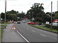
8
40 for not much longer?
The white notice just visible on the street sign on the far side of the road junction is a notice that proposes the reduction of the speed limit on this section from 40 to 30 mph. This is the result of the extensive recent housing development along Spring Lane, part of which is visible on the left.
Image: © Alan Murray-Rust
Taken: 26 May 2021
0.18 miles
9
Top of Spring Lane, Arnold
The lane joins Mapperley Plains here and Spring Lane Farm is on the right
Image: © Tom Courtney
Taken: 9 Aug 2005
0.19 miles
10
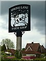
The cow jumped over the house
An attractive metal fretwork sign for the local farm shop.
Image: © Alan Murray-Rust
Taken: 26 May 2021
0.20 miles