IMAGES TAKEN NEAR TO
Plains Road, NOTTINGHAM, NG3 5RH
Introduction
This page details the photographs taken nearby to Plains Road, NG3 5RH by members of the Geograph project.
The Geograph project started in 2005 with the aim of publishing, organising and preserving representative images for every square kilometre of Great Britain, Ireland and the Isle of Man.

There are currently over 7.5m images from over14,400 individuals and you can help contribute to the project by visiting https://www.geograph.org.uk
Image Map
Images are licensed for reuse under creativecommons.org/licenses/by-sa/2.0
Notes
- Clicking on the map will re-center to the selected point.
- The higher the marker number, the further away the image location is from the centre of the postcode.
Image Listing (41 Images Found)
Images are licensed for reuse under creativecommons.org/licenses/by-sa/2.0
Image
Details
Distance
1
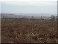
Plains Road Vicinity, Mapperley, Notts.
The Gedling Colliery Cricket Club's ground is at the foot of a short unmade track off Plains Road, near The Mapperley Plains Social Club. Gedling Colliery was closed in October 1991.
Image: © David Hallam-Jones
Taken: 1 Jan 2016
0.05 miles
2
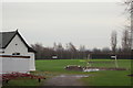
Waste ground on Mapperley Plains
Former farmland which has gone out of production. Looking over Mapperley Golf Course towards Gedling village.
Image: © Alan Murray-Rust
Taken: 1 Feb 2009
0.07 miles
3
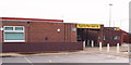
Gym on Plains Road
The name of the cricket club is a reminder that this was a coal mining area.
Image: © Alan Murray-Rust
Taken: 1 Feb 2009
0.07 miles
4

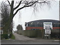
The entrance to Gedling Colliery Cricket Ground
The colliery (200ft or so below its cricket ground on Mapperley Plains) closed in the 1990s, but the cricket club retains its traditional name.
Image: © John Sutton
Taken: 23 Jun 2014
0.07 miles
5
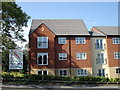
Plains Road, Mapperley, Notts.
The none-to-inspiring premises of a local social club.
Image: © David Hallam-Jones
Taken: 1 Jan 2016
0.09 miles
6
Mapperley Plains Social Club
This was formerly the Gedling Colliery Miners' Welfare.
Image: © Alan Murray-Rust
Taken: 1 Feb 2009
0.10 miles
7

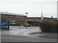
The entrance to Mapperley Plains Social Club
The club is home to a fitness centre, Gedling Colliery Cricket Club and Gedling Miners' Welfare FC, but I took the picture as it shows a friend, a member of Revival, the forthcoming attraction.
Image: © John Sutton
Taken: 23 Jun 2014
0.11 miles
8
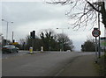
Gedling Road top
The crossroads with Plains Road which runs along the crest of the ridge which is very narrow at this point. Across the lights Arnold Lane drops as steeply away as the rise on this side.
Image: © Alan Murray-Rust
Taken: 1 Feb 2009
0.11 miles
9
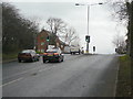
Arnold Lane at Mapperley Plains
This is the opposite side of the junction seen in Image The sharpness of the ridge at this point is very evident.
Image: © Alan Murray-Rust
Taken: 1 Feb 2009
0.11 miles