IMAGES TAKEN NEAR TO
Appleton Gardens, NOTTINGHAM, NG3 5NT
Introduction
This page details the photographs taken nearby to Appleton Gardens, NG3 5NT by members of the Geograph project.
The Geograph project started in 2005 with the aim of publishing, organising and preserving representative images for every square kilometre of Great Britain, Ireland and the Isle of Man.

There are currently over 7.5m images from over14,400 individuals and you can help contribute to the project by visiting https://www.geograph.org.uk
Image Map
Images are licensed for reuse under creativecommons.org/licenses/by-sa/2.0
Notes
- Clicking on the map will re-center to the selected point.
- The higher the marker number, the further away the image location is from the centre of the postcode.
Image Listing (43 Images Found)
Images are licensed for reuse under creativecommons.org/licenses/by-sa/2.0
Image
Details
Distance
1
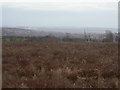
Waste ground on Mapperley Plains
Former farmland which has gone out of production. Looking over Mapperley Golf Course towards Gedling village.
Image: © Alan Murray-Rust
Taken: 1 Feb 2009
0.05 miles
2
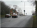
Arnold Lane at Mapperley Plains
This is the opposite side of the junction seen in Image The sharpness of the ridge at this point is very evident.
Image: © Alan Murray-Rust
Taken: 1 Feb 2009
0.08 miles
3
Gedling Road top
The crossroads with Plains Road which runs along the crest of the ridge which is very narrow at this point. Across the lights Arnold Lane drops as steeply away as the rise on this side.
Image: © Alan Murray-Rust
Taken: 1 Feb 2009
0.08 miles
5
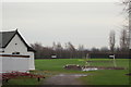
Plains Road Vicinity, Mapperley, Notts.
The Gedling Colliery Cricket Club's ground is at the foot of a short unmade track off Plains Road, near The Mapperley Plains Social Club. Gedling Colliery was closed in October 1991.
Image: © David Hallam-Jones
Taken: 1 Jan 2016
0.09 miles
6
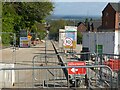
Arnold Lane, Mapperley
Looking down from Plains Road. The road is closed pending the completion of the links to the new roundabout https://www.geograph.org.uk/photo/7164420 at the north end of the Chase Farm development.
Image: © Alan Murray-Rust
Taken: 29 Apr 2022
0.09 miles
7
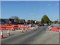
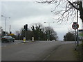
Junction of Plains Road and Arnold Lane
The junction has been completely redesigned following the opening of Colliery Way, with the main flow of north-south traffic now using Mapperley Plains, rather than simply crossing Plains Road.
Image: © Alan Murray-Rust
Taken: 29 Apr 2022
0.10 miles
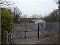
8
Gym on Plains Road
The name of the cricket club is a reminder that this was a coal mining area.
Image: © Alan Murray-Rust
Taken: 1 Feb 2009
0.10 miles
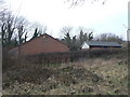
9
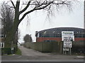
Pepperpots
The scout ground of the 3rd Woodthorpe Scout Group. It takes its name from the two ventilation shafts of the former railway tunnel, one of which can just be seen beyond the main building.
Image: © Alan Murray-Rust
Taken: 1 Feb 2009
0.11 miles
10
Pepperpots
Buildings on the scout ground of the 3rd Woodthorpe Scout Group, the main hall being built in 1997, as seen in the brickwork of the gable 3W 1997.
Image: © Alan Murray-Rust
Taken: 1 Feb 2009
0.11 miles