IMAGES TAKEN NEAR TO
Park House Gates, NOTTINGHAM, NG3 5LX
Introduction
This page details the photographs taken nearby to Park House Gates, NG3 5LX by members of the Geograph project.
The Geograph project started in 2005 with the aim of publishing, organising and preserving representative images for every square kilometre of Great Britain, Ireland and the Isle of Man.

There are currently over 7.5m images from over14,400 individuals and you can help contribute to the project by visiting https://www.geograph.org.uk
Image Map
Images are licensed for reuse under creativecommons.org/licenses/by-sa/2.0
Notes
- Clicking on the map will re-center to the selected point.
- The higher the marker number, the further away the image location is from the centre of the postcode.
Image Listing (29 Images Found)
Images are licensed for reuse under creativecommons.org/licenses/by-sa/2.0
Image
Details
Distance
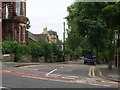
1
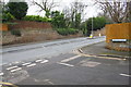
Junction of Woodborough Road and Denmark Grove
Ordnance Survey documents indicate that in 1962 there was a cut mark benchmark levelled at 112.538m above Newlyn Datum on the wall opposite the junction
Image: © Luke Shaw
Taken: 8 Mar 2019
0.01 miles
2
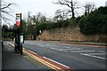
Woodborough Road
Bus stop on the corner of Dagmore Grove.
Image: © Mick Garratt
Taken: 5 Jan 2007
0.04 miles
3
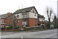
No. 418 Woodborough Road at Dagmar Grove junction
There is an Ordnance survey benchmark Image on the wall pier, right hand face, at the corner of the wall
Image: © Luke Shaw
Taken: 8 Mar 2019
0.04 miles
4
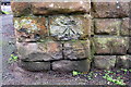
Benchmark on corner pier of wall bounding #418 Woodborough Road
Ordnance Survey documents indicate that in 1962 this cut mark benchmark levelled at 117.351m above Newlyn Datum was present on this pier
Image: © Luke Shaw
Taken: 8 Mar 2019
0.04 miles
7
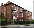
Woodborough Road: a lot of terra cotta
These grand villas on the corner of Dagmar Grove have ornate Romanesque doorways and decorative panels and friezes.
Image: © John Sutton
Taken: 15 Jun 2014
0.06 miles
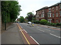
8
Down Woodborough Road
The steep road which links the city (ahead) and Mapperley, seen on an overcast Sunday morning in June.
Image: © John Sutton
Taken: 15 Jun 2014
0.07 miles
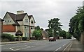
9
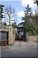
'Riseholme', The Crescent
There is an OS benchmark Image on a stone in the wall to the right of the right hand gatepost
Image: © Roger Templeman
Taken: 31 Mar 2013
0.09 miles
10
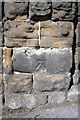
Benchmark on wall on NW side of Woodborough Road
Ordnance Survey cut mark benchmark described on the Bench Mark Database at http://www.bench-marks.org.uk/bm47883
Image: © Roger Templeman
Taken: 31 Mar 2013
0.09 miles