IMAGES TAKEN NEAR TO
Ransom Road, NOTTINGHAM, NG3 5HN
Introduction
This page details the photographs taken nearby to Ransom Road, NG3 5HN by members of the Geograph project.
The Geograph project started in 2005 with the aim of publishing, organising and preserving representative images for every square kilometre of Great Britain, Ireland and the Isle of Man.

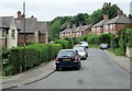
There are currently over 7.5m images from over14,400 individuals and you can help contribute to the project by visiting https://www.geograph.org.uk
Image Map
Images are licensed for reuse under creativecommons.org/licenses/by-sa/2.0
Notes
- Clicking on the map will re-center to the selected point.
- The higher the marker number, the further away the image location is from the centre of the postcode.
Image Listing (30 Images Found)
Images are licensed for reuse under creativecommons.org/licenses/by-sa/2.0
Image
Details
Distance
1
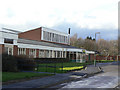
Springwood Day Centre
Providing community facilities for people with various disabilities.
Image: © Alan Murray-Rust
Taken: 8 Mar 2009
0.05 miles
2
Ransom Drive
Recent housing (2017-18) on the site of the former Springwood Centre https://www.geograph.org.uk/photo/1197640 https://www.geograph.org.uk/photo/1197610 .
Image: © Alan Murray-Rust
Taken: 27 Nov 2022
0.07 miles
3
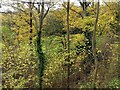
Coppice Park
A small area of open space, opened in 1905 on the site of a former rifle range.
Image: © Alan Murray-Rust
Taken: 27 Nov 2022
0.07 miles
4
Ransom Drive
The approach road to the former Coppice Hospital (now Hine Hall), which is silhouetted. Also visible is the Springwood day Centre.
Image: © Alan Murray-Rust
Taken: 8 Mar 2009
0.07 miles
5
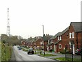
Mapperley: Caunton Avenue
A street of pre-war council houses off Ransom Road. A large St George's cross flaps from one of the houses - England had lost their opening match of the 2014 World Cup the night before.
Image: © John Sutton
Taken: 15 Jun 2014
0.08 miles
6
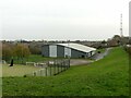
Mapperley Sports Village
A mixture of mixed sports indoor and outdoor facilities.
Image: © Alan Murray-Rust
Taken: 27 Nov 2022
0.09 miles
7
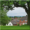
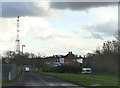
Mapperley Top to Ratcliffe-on-Soar
A view from Ransom Road, near the top of the Mapperley ridge, with the chimney and cooling towers of Ratcliffe-on-Soar power station in the distance. The spot height nearby is 112m/368ft, so there are long views over the Trent Valley to the south-west and to the Vale of Belvoir to the south-east.
For comparison, see Alan Murray-Rust's Image], taken with a more powerful zoom lens.
Image: © John Sutton
Taken: 15 Jun 2014
0.09 miles
8
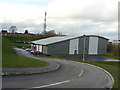
Mapperley Sports Village
A slightly pretentious name for what is effectively a multi-sports hall. Attached to Elliot Durham School.
Image: © Alan Murray-Rust
Taken: 8 Mar 2009
0.09 miles
9
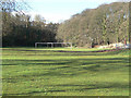
Coppice Recreation Ground
This a knockabout football pitch - it's too small for formal competition.
Image: © Alan Murray-Rust
Taken: 8 Mar 2009
0.09 miles
10
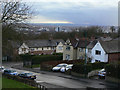
Top of Ransom Road
The high ground to the north east of Nottingham City Centre provides fine views over the Trent Valley and beyond - even when the weather is not at its best.
Image: © Alan Murray-Rust
Taken: 8 Mar 2009
0.10 miles