IMAGES TAKEN NEAR TO
Morley Avenue, NOTTINGHAM, NG3 5FZ
Introduction
This page details the photographs taken nearby to Morley Avenue, NG3 5FZ by members of the Geograph project.
The Geograph project started in 2005 with the aim of publishing, organising and preserving representative images for every square kilometre of Great Britain, Ireland and the Isle of Man.

There are currently over 7.5m images from over14,400 individuals and you can help contribute to the project by visiting https://www.geograph.org.uk
Image Map
Images are licensed for reuse under creativecommons.org/licenses/by-sa/2.0
Notes
- Clicking on the map will re-center to the selected point.
- The higher the marker number, the further away the image location is from the centre of the postcode.
Image Listing (74 Images Found)
Images are licensed for reuse under creativecommons.org/licenses/by-sa/2.0
Image
Details
Distance
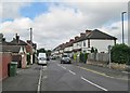
2
Mapperley Rise
Looking down this steep road which links Sherwood and Mapperley Top. The east of the city is hilly and there is a long view across Sherwood and Basford to the hills beyond Strelley which separate Nottingham from the Erewash Valley.
Image: © John Sutton
Taken: 17 Jun 2014
0.06 miles
3
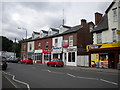
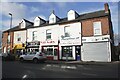
Shops on Woodborough Road, Mapperley
This short parade of shops is somewhat in the shadow of the more comprehensive district centre about a mile further out of the city and over the boundary into the county.
Image: © Richard Vince
Taken: 14 Jul 2012
0.06 miles
4
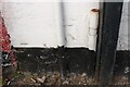
Benchmark on No. 517 Woodborough Road
Ordnance Survey cut mark benchmark levelled at 127.135m above Newlyn Datum in 1962
Image: © Luke Shaw
Taken: 1 Feb 2020
0.06 miles
5
Row of shops on NW side of Woodborough Road
There is an Ordnance Survey benchmark Image on the front, left hand end, of the 'PhoneShop UK' shop
Image: © Luke Shaw
Taken: 1 Feb 2020
0.06 miles
6
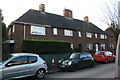
Mapperley: Morley Avenue
Off Mapperley Rise, just north of Woodborough Road on the hilly eastern side of the city.
Image: © John Sutton
Taken: 17 Jun 2014
0.06 miles
7
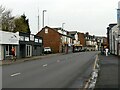
Woodborough Road, Mapperley
Typical Nottingham suburban main road with development from around 1900, sustained by the fact that this was an early electric tram route.
Image: © Alan Murray-Rust
Taken: 27 Nov 2022
0.06 miles
8
Maurice Drive, Mapperley
A residential cul de sac off Mapperley Rise.
Image: © Richard Vince
Taken: 14 Jul 2012
0.06 miles
9
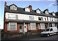
Nos. 34 to 28 (evens) Morley Avenue
Ordnance Survey documents indicate that a benchmark was levelled at 116.778m above Newlyn Datum in 1962 on the side of the left hand house at its front corner
Image: © Luke Shaw
Taken: 1 Feb 2020
0.07 miles
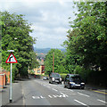
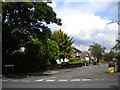
10
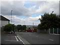
Looking down Mapperley Rise
At this point, Mapperley Rise begins to descend gently from Woodborough Road (behind the photographer) towards Sherwood; the descent becomes alarmingly steep a little further on.
Image: © Richard Vince
Taken: 14 Jul 2012
0.07 miles