IMAGES TAKEN NEAR TO
Byford Close, NOTTINGHAM, NG3 5FX
Introduction
This page details the photographs taken nearby to Byford Close, NG3 5FX by members of the Geograph project.
The Geograph project started in 2005 with the aim of publishing, organising and preserving representative images for every square kilometre of Great Britain, Ireland and the Isle of Man.

There are currently over 7.5m images from over14,400 individuals and you can help contribute to the project by visiting https://www.geograph.org.uk
Image Map
Images are licensed for reuse under creativecommons.org/licenses/by-sa/2.0
Notes
- Clicking on the map will re-center to the selected point.
- The higher the marker number, the further away the image location is from the centre of the postcode.
Image Listing (68 Images Found)
Images are licensed for reuse under creativecommons.org/licenses/by-sa/2.0
Image
Details
Distance
1
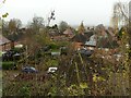
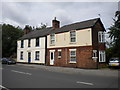
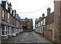
Byford and Blaydon Closes, Mapperley
The houses are the typical pattern of Nottingham council housing of the inter-war period.
This view is taken from Woodborough Road, and the marked difference in levels is due to the fact that this was the site of one of the many brickworks along the Mapperley ridge. Mapping shows that it had been worked out by the early years of the 20th century.
Image: © Alan Murray-Rust
Taken: 27 Nov 2022
0.02 miles
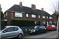
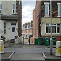
2
Housing on Bladon Close, Mapperley
The southern end of this small council estate is seen here from Private Road on its final ascent to Woodborough Road. The housing in this estate appears to be typical Nottingham architecture from the 1930s, and if memory serves is similar to that around Wollaton Road and Western Boulevard.
Image: © Richard Vince
Taken: 14 Jul 2012
0.03 miles
3
Nos. 34 to 28 (evens) Morley Avenue
Ordnance Survey documents indicate that a benchmark was levelled at 116.778m above Newlyn Datum in 1962 on the side of the left hand house at its front corner
Image: © Luke Shaw
Taken: 1 Feb 2020
0.03 miles
4
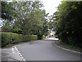
Gordon Rise, Mapperley
Seen from Private Road (which actually continues as the turning to the left in the foreground), Gordon Rise appears unpopulated. However, it is surrounding by housing, albeit at a different level from the road at this point.
Image: © Richard Vince
Taken: 14 Jul 2012
0.05 miles
5
Haphazard houses on Woodborough Road
While the house on the left appears to be substantially as built, the one on the right looks as though it has been substantially altered, and may in fact be two separate dwellings. Indeed, the shape of the roof suggests that it may once have been the end of a longer terrace of houses.
Image: © Richard Vince
Taken: 14 Jul 2012
0.06 miles
6
Mapperley: Agnes Villas
A view across Woodborough Road. For comparison, see Alan Murray-Rust's Image
Image: © John Sutton
Taken: 17 Jun 2014
0.07 miles
7
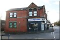
No. 620 Woodborough Road (Crystal Blinds) at Mission Street junction
There is an Ordnance Survey benchmark Image on the brick section of the shop left of a downpipe
Image: © Luke Shaw
Taken: 1 Feb 2020
0.08 miles
8
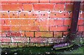
Benchmark on No. 620 Woodborough Road (Mission Street face)
Ordnance Survey cut mark benchmark on Crystal Blinds shop levelled at 126.739m above Newlyn Datum in 1962
Image: © Luke Shaw
Taken: 1 Feb 2020
0.08 miles
9
Agnes Villas
When built, these houses would have been sought after, with the luxury of a bay window giving extra space, and a convenient tram service into town just through the alleyway. Today, without any parking space adjacent they will be far less attractive (although the bus service is still frequent).
Image: © Alan Murray-Rust
Taken: 8 Mar 2009
0.09 miles
10
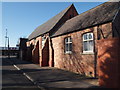
Nottingham NG5 - Mapperley
This combined mission church and school was built c.1863-65 and was originally called St Ann's C. of E. School. Following the construction of the nearby St Jude's Anglican Curch, Mapperley it was renamed St Judes's C. of E. School. Attendances rose and money was found to extend the buildings in 1881 and again in 1892 when the numbers on the register reached 250. By 1901 however, the ever increasing pressure on the facilities forced the local education authority to press the school management to improve the facilities still further and to include an infants' section. The church however, was unable to fund any further developments and children from the nearby new Porchester housing estate could not be admitted. The school became an infants and junior school in 1928 but it eventually closed in 1935 with only 170 children registered. Because of these low numbers it was decided to close these premises and for children to begin, instead, to enrol at new nearby Walter Halls School. The (unused) main entrance is on Woodborough Road. These premises are currently occupied by a painting and decorating supplies business.
Image: © David Hallam-Jones
Taken: 11 Mar 2012
0.09 miles