IMAGES TAKEN NEAR TO
Sefton Drive, NOTTINGHAM, NG3 5ER
Introduction
This page details the photographs taken nearby to Sefton Drive, NG3 5ER by members of the Geograph project.
The Geograph project started in 2005 with the aim of publishing, organising and preserving representative images for every square kilometre of Great Britain, Ireland and the Isle of Man.

There are currently over 7.5m images from over14,400 individuals and you can help contribute to the project by visiting https://www.geograph.org.uk
Image Map
Images are licensed for reuse under creativecommons.org/licenses/by-sa/2.0
Notes
- Clicking on the map will re-center to the selected point.
- The higher the marker number, the further away the image location is from the centre of the postcode.
Image Listing (62 Images Found)
Images are licensed for reuse under creativecommons.org/licenses/by-sa/2.0
Image
Details
Distance
1
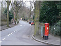
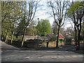
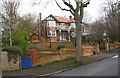
Sefton Drive
Typical tree-lined road in Mapperley Park
Image: © Alan Murray-Rust
Taken: 15 Mar 2009
0.03 miles
2
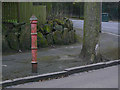
Fire Hydrant, Mapperley Hall Drive.
This was the typical traditional hydrant type in use in Nottingham. There are now very few of them around.
Image: © Alan Murray-Rust
Taken: 15 Mar 2009
0.06 miles
3
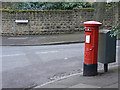
Pillar box, Sefton Drive
Standard GR pillar box on the corner of Sefton Drive and Mapperley Hall Drive.
Image: © Alan Murray-Rust
Taken: 15 Mar 2009
0.07 miles
4
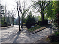
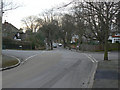
Mapperley Park: Old Hall Drive
Mapperley Park, long the home of Nottingham's prosperous, is the quintessential leafy suburb. This is the junction of Mapperley Hall Drive and Old Hall Drive, a steep and narrow cul de sac at the top end of which my Auntie Ethel and Uncle Harold lived in the 1960s.
Image: © John Sutton
Taken: 23 Apr 2010
0.07 miles
5
Mapperley Park: leafiest of suburbs
In a grand suburb consisting mainly of substantial late Victorian and Edwardian houses, this large bungalow on the corner of Hatfield Road and Sefton Drive, built perhaps in the 1950s or 60s, is the exception.
Image: © John Sutton
Taken: 23 Apr 2010
0.08 miles
6
Mapperley Park: Cyprus Road
Up the hill from the corner of Mapperley Hall Drive.
Image: © John Sutton
Taken: 23 Apr 2010
0.08 miles
7
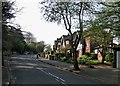
Mapperley Hall Drive
Typical view in Mapperley Park with tree-lined roads and laerge houses.
Image: © Alan Murray-Rust
Taken: 15 Mar 2009
0.11 miles
8
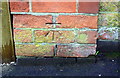
Benchmark on wall pier beside gate of #47 Mapperley Hall Drive
Ordnance Survey documents indicate that in 1962 this cut mark benchmark levelled at 91.193m above Newlyn Datum was present on this wall pier
Image: © Luke Shaw
Taken: 8 Mar 2019
0.14 miles
9
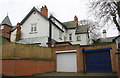
No. 47 Mapperley Hall Drive at Woodland Drive junction
There is an Ordnance Survey benchmark Image on the brick pier on the right hand side of the blue gate
Image: © Luke Shaw
Taken: 8 Mar 2019
0.15 miles
10
Garages of No. 8 Private Road
There is an Ordnance Survey cut mark benchmark Image in the bricks on the right hand side of the garage with the white door
Image: © Luke Shaw
Taken: 8 Mar 2019
0.16 miles