IMAGES TAKEN NEAR TO
Esher Grove, NOTTINGHAM, NG3 5DR
Introduction
This page details the photographs taken nearby to Esher Grove, NG3 5DR by members of the Geograph project.
The Geograph project started in 2005 with the aim of publishing, organising and preserving representative images for every square kilometre of Great Britain, Ireland and the Isle of Man.

There are currently over 7.5m images from over14,400 individuals and you can help contribute to the project by visiting https://www.geograph.org.uk
Image Map
Images are licensed for reuse under creativecommons.org/licenses/by-sa/2.0
Notes
- Clicking on the map will re-center to the selected point.
- The higher the marker number, the further away the image location is from the centre of the postcode.
Image Listing (143 Images Found)
Images are licensed for reuse under creativecommons.org/licenses/by-sa/2.0
Image
Details
Distance
1
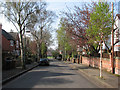
Mapperley Park: Alverstone Road
Alverstone Road leads down to Esher Grove and the gateway leading to the green expanse of the Hyson Green and Carrington Sports Club ground, formerly the Nottingham City Police Training Ground.
Image: © John Sutton
Taken: 23 Apr 2010
0.03 miles
2
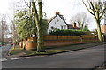
No.8 Mapperley Hall Drive
There is an Ordnance Survey benchmark Image on a stone at the base of the brick wall near its corner
Image: © Luke Shaw
Taken: 8 Mar 2019
0.06 miles
3
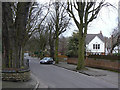
Mapperley Hall Drive
Typical tree-lined road in Mapperley Park, an area of large houses mainly from the end of the 19th, beginning of the 20th centuries.
Image: © Alan Murray-Rust
Taken: 15 Mar 2009
0.06 miles
4
Carisbrooke Drive
This road includes some of the newer properties in Mapperley Park.
Image: © Alan Murray-Rust
Taken: 15 Mar 2009
0.06 miles
5
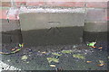
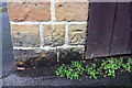
Benchmark on stone in brick wall outside #8 Mapperley Hall Drive
Ordnance Survey documents indicate that in 1962 this cut mark benchmark was levelled at 69.549m above Newlyn Datum.
Image: © Luke Shaw
Taken: 8 Mar 2019
0.06 miles
6
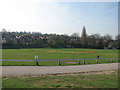
Carrington Sports Ground, Mansfield Road
Now the Hyson Green & Carrington Sports Club, this long-established cricket ground was once the Nottingham City Police Training Ground, where I spent a fair amount of time as a child, watching my father play for the all-conquering Police side (all six-footers) which won the Notts Amateur League several times in the years after the War. This view is taken across the ground, which is scooped out of the sandstone, towards the houses on Carisbrooke Drive. (There are fierce notices threatening trespassers with prosecution, so it should be recorded that I had been invited on to the ground for a Proustian moment or two.)
Image: © John Sutton
Taken: 23 Apr 2010
0.06 miles
7
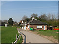
Carrington Sports Ground, Mansfield Road: the pavilion
Now the Hyson Green & Carrington Sports Club, this long-established cricket ground was once the Nottingham City Police Training Ground, where I spent a fair amount of time as a child, watching my father play for the all-conquering Police side (all six-footers) which won the Notts Amateur League several times in the years after the War. In those days the low, green-painted wooden pavilion was long on charm (and Mrs Creswick's fine teas), but had more primitive facilities than its smart lottery-funded replacement. (There are fierce notices threatening trespassers with prosecution, so it should be recorded that I had been invited on to the ground for a Proustian moment or two.)
Image: © John Sutton
Taken: 23 Apr 2010
0.07 miles
8
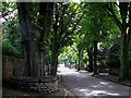
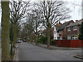
Mapperley Hall Drive
Alverstone Road is just ahead on the right. The sun was just breaking through after an overcast start to a July morning.
Image: © John Sutton
Taken: 18 Jul 2016
0.07 miles
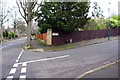
9
Benchmark on wall at west end of Carisbrooke Avenue
Ordnance Survey cut mark benchmark described on the Bench Mark Database at www.bench-marks.org.uk/bm118642
Image: © Luke Shaw
Taken: 15 Apr 2020
0.07 miles
10
Junction of Carisbrooke Avenue and Carisbrooke Drive
There is an Ordnance Survey benchmark Image on the brick wall pier at the junction
Image: © Luke Shaw
Taken: 15 Apr 2020
0.07 miles