IMAGES TAKEN NEAR TO
Alverston Road, NOTTINGHAM, NG3 5DQ
Introduction
This page details the photographs taken nearby to Alverston Road, NG3 5DQ by members of the Geograph project.
The Geograph project started in 2005 with the aim of publishing, organising and preserving representative images for every square kilometre of Great Britain, Ireland and the Isle of Man.

There are currently over 7.5m images from over14,400 individuals and you can help contribute to the project by visiting https://www.geograph.org.uk
Image Map
Images are licensed for reuse under creativecommons.org/licenses/by-sa/2.0
Notes
- Clicking on the map will re-center to the selected point.
- The higher the marker number, the further away the image location is from the centre of the postcode.
Image Listing (146 Images Found)
Images are licensed for reuse under creativecommons.org/licenses/by-sa/2.0
Image
Details
Distance
1
No.8 Mapperley Hall Drive
There is an Ordnance Survey benchmark Image on a stone at the base of the brick wall near its corner
Image: © Luke Shaw
Taken: 8 Mar 2019
0.01 miles
2
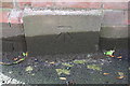
Benchmark on stone in brick wall outside #8 Mapperley Hall Drive
Ordnance Survey documents indicate that in 1962 this cut mark benchmark was levelled at 69.549m above Newlyn Datum.
Image: © Luke Shaw
Taken: 8 Mar 2019
0.02 miles
3
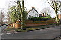
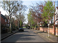
Mapperley Hall Drive
Typical tree-lined road in Mapperley Park, an area of large houses mainly from the end of the 19th, beginning of the 20th centuries.
Image: © Alan Murray-Rust
Taken: 15 Mar 2009
0.02 miles
4
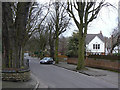
Mapperley Hall Drive
Alverstone Road is just ahead on the right. The sun was just breaking through after an overcast start to a July morning.
Image: © John Sutton
Taken: 18 Jul 2016
0.03 miles
5
Mapperley Park: Alverstone Road
Alverstone Road leads down to Esher Grove and the gateway leading to the green expanse of the Hyson Green and Carrington Sports Club ground, formerly the Nottingham City Police Training Ground.
Image: © John Sutton
Taken: 23 Apr 2010
0.03 miles
6
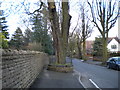
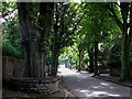
Captive tree on Mapperley Hall Drive
Negotiating one's way past this tree while remaining on the pavement is not easy.
Image: © Richard Vince
Taken: 12 Apr 2010
0.03 miles
7

Nottingham - Mapperley Park NG5
A view along Mapperley Hall Drive with Mansfield Rd (A60) behind the photographer's back. Just visible on the left hand side is "Miriam Kaplowitch House", a defunct residential home for elderly Jewish people awaiting a buyer and re-development. Miriam Kaplowitch (nee Kaufman) was involved in setting up hostels for Jewish women who had fled from Nazi Germany. She also helped to set up the Nottingham branch of Society for the Prevention of Cruelty to Children.
Image: © David Hallam-Jones
Taken: 15 Mar 2012
0.03 miles
8
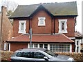
House with a crest
This unusual crested house is in Mapperley Hall Drive.
Image: © Michael Dibb
Taken: 30 Mar 2017
0.04 miles
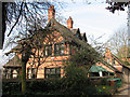
9

Victorian house, Mapperley Hall Drive
Mapperley Park is an area full of large houses from the late Victorian and Edwardian periods.
Image: © Alan Murray-Rust
Taken: 15 Mar 2009
0.04 miles
10
Watson Fothergill's Clawson Lodge, Mansfield Road
Fothergill's lovely house, Clawson Lodge, is now the Ukrainian Cultural Centre. In the 1950s my Auntie Ethel and Uncle Harold lived in some splendour in the top-floor flat. Fothergill characteristics include the heavy bargeboards, the black timbering, the fine red and blue brickwork, the tall chimney stacks and the leaded lights. This picture shows the back of the house and its outbuildings; for views of the front and the lychgate-like entrance gate, see Alan Murray-Rust's pictures http://www.geograph.org.uk/photo/1211550 http://www.geograph.org.uk/photo/1211527.
Image: © John Sutton
Taken: 23 Apr 2010
0.05 miles