IMAGES TAKEN NEAR TO
Magdala Road, NOTTINGHAM, NG3 5DD
Introduction
This page details the photographs taken nearby to Magdala Road, NG3 5DD by members of the Geograph project.
The Geograph project started in 2005 with the aim of publishing, organising and preserving representative images for every square kilometre of Great Britain, Ireland and the Isle of Man.

There are currently over 7.5m images from over14,400 individuals and you can help contribute to the project by visiting https://www.geograph.org.uk
Image Map
Images are licensed for reuse under creativecommons.org/licenses/by-sa/2.0
Notes
- Clicking on the map will re-center to the selected point.
- The higher the marker number, the further away the image location is from the centre of the postcode.
Image Listing (137 Images Found)
Images are licensed for reuse under creativecommons.org/licenses/by-sa/2.0
Image
Details
Distance
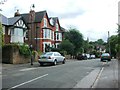
1
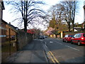
View north along Zulla Road
Taken from just north of the junction with Magdala Road. The junction with Shirley Road is just beyond the very pink, very blossom laden tree on the right.
Image: © Richard Vince
Taken: 12 Apr 2010
0.01 miles
2
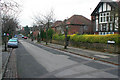
Zulla Road, Mapperley Park
Mapperley Park is a Conservation Area with a wealth of late Victorian and Edwardian housing on tree lined streets. Within easy walking distance of the city centre it is a popular area to live and many of the large houses on the south of the "estate" have been converted into flats. Zulla Road, on the south western side, is one of only two roads in the Nottingham area beginning with "Z". The other is Zulu Road a couple of kilometres west in Image
Many of the roads in Mapperley Park are named after 19th Century military campaigns. Zulla was a small fishing village in Annesley Bay on the Abyssinian coast, (now Ethiopia). The village became the landing point during the 1868 campaign to rescue British hostages from the mountain fortress of Magdala. An account of this campaign, initiated by a "diplomatic incident" between King Theodore II of Abyssinia and the British Government, can be found at http://www.britishempire.co.uk/forces/armycampaigns/africancampaigns/campabyssinia.htm
Zulla Road joins Magdala Road at its southern end.
Image: © Kate Jewell
Taken: 3 Jan 2008
0.03 miles
3
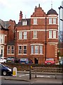
Corner turret
This former house with corner turret and Dutch gable is now part of the Westminster Hotel.
Image: © Michael Dibb
Taken: 30 Mar 2017
0.03 miles
7
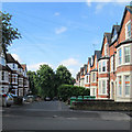
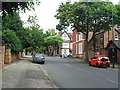
Mapperley Park Drive
Grand terraces line a road linking Magdala Road and Redcliffe Road (ahead).
Image: © John Sutton
Taken: 17 Jun 2014
0.06 miles
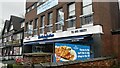
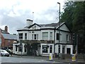
8
Mansfield Road: The Grosvenor
Decorated for England's unsuccessful World Cup campaign in Brazil and photographed on the grey morning after the 1-2 defeat to Italy in the opening game.
Image: © John Sutton
Taken: 15 Jun 2014
0.07 miles
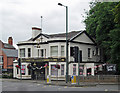
10
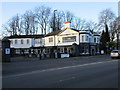
The Grosvenor
At the junction of Mansfield Road and Hucknall Road.
Image: © Jonathan Thacker
Taken: 15 Jan 2016
0.08 miles