IMAGES TAKEN NEAR TO
Elm Close, NOTTINGHAM, NG3 5AH
Introduction
This page details the photographs taken nearby to Elm Close, NG3 5AH by members of the Geograph project.
The Geograph project started in 2005 with the aim of publishing, organising and preserving representative images for every square kilometre of Great Britain, Ireland and the Isle of Man.

There are currently over 7.5m images from over14,400 individuals and you can help contribute to the project by visiting https://www.geograph.org.uk
Image Map
Images are licensed for reuse under creativecommons.org/licenses/by-sa/2.0
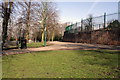
Notes
- Clicking on the map will re-center to the selected point.
- The higher the marker number, the further away the image location is from the centre of the postcode.
Image Listing (263 Images Found)
Images are licensed for reuse under creativecommons.org/licenses/by-sa/2.0
Image
Details
Distance
1
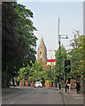
Mapperley Road and St Andrew's Church spire
A slightly foreshortened view towards Mansfield Road. St Andrew's Church dates from 1869-71 and is a prominent landmark on the north side of the city.
Image: © John Sutton
Taken: 1 Jul 2015
0.03 miles
2
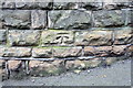
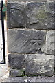
Benchmark on the wall of Mapperley Road at Elm Bank junction
Ordnance Survey cut mark benchmark described on the Bench Mark Database at http://www.bench-marks.org.uk/bm47946
Image: © Roger Templeman
Taken: 1 Apr 2013
0.03 miles
3
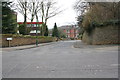
Junction of Mapperley Road and Elm Bank
There is an OS benchmark Image on the wall at the right hand side of the image
Image: © Roger Templeman
Taken: 1 Apr 2013
0.03 miles
4
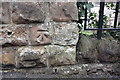
Benchmark on wall outside school of Elm Bank
Ordnance Survey cut mark benchmark described on the Bench Mark Database at http://www.bench-marks.org.uk/bm47944
Image: © Roger Templeman
Taken: 1 Apr 2013
0.04 miles
5
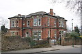
Former Special Care School, Elm Bank
There is an OS benchmark Image on a stone in the wall left of the junction with the low wall with railings on top
Image: © Roger Templeman
Taken: 1 Apr 2013
0.05 miles
6
Benchmark on wall fronting #27 Mapperley Road
Ordnance Survey cut mark benchmark described on the Bench Mark Database at http://www.bench-marks.org.uk/bm47856
Image: © Roger Templeman
Taken: 1 Apr 2013
0.05 miles
7
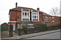
#27 Mapperley Road
There is an OS benchmark Image on a wall stone to the right of the pedestrian gate
Image: © Roger Templeman
Taken: 1 Apr 2013
0.05 miles
8
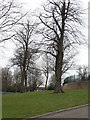
Corporation Oaks
The circuit around the Belle Vue reservoir (to the right) is called Corporation Oaks, but these trees look more like lime trees to me. This is part of the green corridor created in the 1870s stretching from the Arboretum to St Anns Well Road.
Image: © Alan Murray-Rust
Taken: 8 Mar 2009
0.05 miles
9
Junction of Elm Avenue and path around Bellevue Reservoir
There is an OS benchmark Image on the wall of the covered reservoir opposite the top of Elm Avenue
Image: © Roger Templeman
Taken: 31 Mar 2013
0.06 miles
10

Corporation Oaks at Belle Vue Reservoir
There is a benchmark https://www.geograph.org.uk/photo/7353544 below the graffiti to the right.
Image: © Alan Murray-Rust
Taken: 27 Nov 2022
0.06 miles