IMAGES TAKEN NEAR TO
Furze Gardens, NOTTINGHAM, NG3 4QH
Introduction
This page details the photographs taken nearby to Furze Gardens, NG3 4QH by members of the Geograph project.
The Geograph project started in 2005 with the aim of publishing, organising and preserving representative images for every square kilometre of Great Britain, Ireland and the Isle of Man.

There are currently over 7.5m images from over14,400 individuals and you can help contribute to the project by visiting https://www.geograph.org.uk
Image Map
Images are licensed for reuse under creativecommons.org/licenses/by-sa/2.0
Notes
- Clicking on the map will re-center to the selected point.
- The higher the marker number, the further away the image location is from the centre of the postcode.
Image Listing (95 Images Found)
Images are licensed for reuse under creativecommons.org/licenses/by-sa/2.0
Image
Details
Distance
1
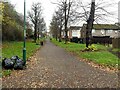
Robin Hood Chase, looking north from Abbotsford Drive Subway
Part of the series of pedestrian avenues created in 1851 as a result of the recent Inclosures to the north of the City centre. These are lime trees.
Image: © Alan Murray-Rust
Taken: 27 Nov 2022
0.06 miles
2
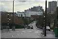
Abbotsford Drive
Looking towards the City Centre, with the Victoria Centre flats on the skyline. This road was created from scratch as part of the St Anns redevelopment of the 1970s and is a main feeder road for the area.
Image: © Alan Murray-Rust
Taken: 8 Mar 2009
0.06 miles
3
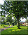
Down Robin Hood Chase
In 1833 a Select Committee on Public Walks recommended the creation of “properly regulated” public walks for the “middle and humbler classes” in order to improve “their cleanliness, neatness and personal appearance” and provide a venue for a man to show off his wife and well-behaved children. Such walks were seen as an alternative to the “drinking shops, where, in short-lived excitement, they may forget their toil, but where they waste the means of their families and too often destroy their health”.
It became possible to implement these recommendations after the 1845 Enclosure Act, and by 1852 walks and other green spaces had been established in an arc north of the town centre, from Robin Hood Chase in the east, along Corporation Oaks and Elm Avenue to the Arboretum and the General Cemetery. The Forest recreation ground was also established.
A journalist then wrote that “Nottingham might vie with any town in England for its well-grown and well-dressed women of the operative classes who on Sunday throng the park and public walks.”
(All of this information comes from “The transformation of green space in old and new Nottingham” in Volume 118 of the Transactions of the Thoroton Society.)
Image: © John Sutton
Taken: 1 Jul 2015
0.07 miles
4

Chasewood baptist Church
Not recognised on the 1:50000 map, although it does feature on the 1:25000
Image: © Alan Murray-Rust
Taken: 8 Mar 2009
0.08 miles
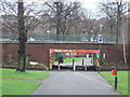
5
Abbotsford Drive crossing Robin Hood Chase
The Chase is one of the areas comprising the 130 acres of land to the north and east of Nottingham city centre set aside by the 1845 Enclosure Act as public open space.
Image: © Stephen Craven
Taken: 18 Jan 2020
0.08 miles
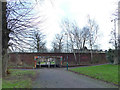
6
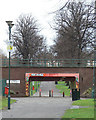
Subway on Robin Hood Chase
The Chase is crossed here by Abbotsford Drive. The bridge has been decorated with murals inside and out. Image, Image
Image: © Alan Murray-Rust
Taken: 8 Mar 2009
0.08 miles
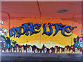
7

More Love
Image: © Alan Murray-Rust
Taken: 8 Mar 2009
0.08 miles
8
Subway at Abbotsford Drive
Image: © Alan Murray-Rust
Taken: 8 Mar 2009
0.08 miles
9
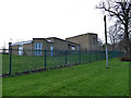
Chasewood Baptist Church
An uninspiring modern building, looking much as it did eleven years ago Image
Image: © Stephen Craven
Taken: 18 Jan 2020
0.09 miles
10
More Life
Image: © Alan Murray-Rust
Taken: 8 Mar 2009
0.09 miles