IMAGES TAKEN NEAR TO
St. Anns Hill, NOTTINGHAM, NG3 4LA
Introduction
This page details the photographs taken nearby to St. Anns Hill, NG3 4LA by members of the Geograph project.
The Geograph project started in 2005 with the aim of publishing, organising and preserving representative images for every square kilometre of Great Britain, Ireland and the Isle of Man.

There are currently over 7.5m images from over14,400 individuals and you can help contribute to the project by visiting https://www.geograph.org.uk
Image Map
Images are licensed for reuse under creativecommons.org/licenses/by-sa/2.0
Notes
- Clicking on the map will re-center to the selected point.
- The higher the marker number, the further away the image location is from the centre of the postcode.
Image Listing (177 Images Found)
Images are licensed for reuse under creativecommons.org/licenses/by-sa/2.0
Image
Details
Distance
1
Looking up Robin Hood Chase
The houses at the top are on Woodborough Road.
Robin Hood Chase is part of the green corridor stretching round the north and east of the City Centre from the Arboretum to St Anns Well Road, built around the 1870s.
Image: © Alan Murray-Rust
Taken: 8 Mar 2009
0.02 miles
2
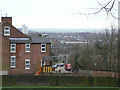
View from Belle Vue
Looking over St Anns towards Sneinton.
Image: © Alan Murray-Rust
Taken: 8 Mar 2009
0.03 miles
3
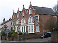
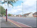
Nottingham - terrace on Woodborough Road
At junction with St Anns Hill.
Image: © Dave Bevis
Taken: 25 Feb 2013
0.03 miles
4

Woodborough Road and St Augustine's Church
A view down Woodborough Road towards the stern front and Byzantine domes of St Augustine of England RC Church. Further away in the city centre the tower blocks of the Victoria Centre dominate the lower end of Mansfield Road.
Image: © John Sutton
Taken: 23 Jun 2014
0.04 miles
5
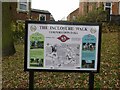
The Inclosure Walk, no.5
One of a series of boards at key locations around the walk described on the board, taking in the main locations associated with the mid 19th century Inclosures of the borough.
Image: © Alan Murray-Rust
Taken: 27 Nov 2022
0.04 miles
6
Nottingham - NG3 (Alexandra Pk)
The remains of a lamp post (?) at the side of Woodborough Road near St Ann's Hill, on the descent towards Mapperley.
Image: © David Hallam-Jones
Taken: 10 Jun 2012
0.04 miles
7
Notice of rights of way, entrance to Corporation Oaks
The status of the walks along Robin Hood Chase, Corporation Oaks and Elm Avenue has recently changed: Nottingham City Council has designated this as public rights of way and cyclepaths.
Image: © SK53
Taken: 26 Apr 2011
0.04 miles
8

Corporation Oaks
Looking towards Woodborough Road on a bright June morning.
Image: © John Sutton
Taken: 23 Jun 2014
0.04 miles
9
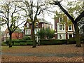
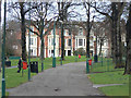
Victorian villas alongside Corporation Oaks
At the time these would have been prestigious sites. At first sight the lack of vehicle access to the frontage might appear problematical, especially in the age of the motor car, but in practice the houses are all served at the rear, some with original Victorian coach houses.
Image: © Alan Murray-Rust
Taken: 27 Nov 2022
0.04 miles
10
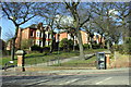
Junction of Woodborough Road and Corporation Oaks
There is an OS benchmark Image on the wall to the right of the wall pier to the right of the telephone kiosk
Image: © Roger Templeman
Taken: 31 Mar 2013
0.05 miles