IMAGES TAKEN NEAR TO
Park Avenue, NOTTINGHAM, NG3 4JS
Introduction
This page details the photographs taken nearby to Park Avenue, NG3 4JS by members of the Geograph project.
The Geograph project started in 2005 with the aim of publishing, organising and preserving representative images for every square kilometre of Great Britain, Ireland and the Isle of Man.

There are currently over 7.5m images from over14,400 individuals and you can help contribute to the project by visiting https://www.geograph.org.uk
Image Map
Images are licensed for reuse under creativecommons.org/licenses/by-sa/2.0
Notes
- Clicking on the map will re-center to the selected point.
- The higher the marker number, the further away the image location is from the centre of the postcode.
Image Listing (129 Images Found)
Images are licensed for reuse under creativecommons.org/licenses/by-sa/2.0
Image
Details
Distance
1
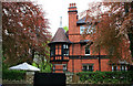
"Beechwood"
A Watson Fothergill house on Mapperley Road, dating from 1904.
Image: © David Lally
Taken: 6 May 2010
0.03 miles
2
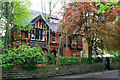
"Beechwood"
A house by Watson Fothergill, from 1904.
Image: © David Lally
Taken: 6 May 2010
0.03 miles
3
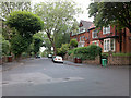
Vickers Street
From its junction with Goresy Road.
Image: © David Lally
Taken: 12 Jun 2009
0.04 miles
6
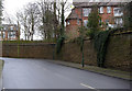
Retaining wall, Redcliffe Road
A fine piece of mid/late 19th century masonry in the local (possibly Bulwell) stone.
Image: © Alan Murray-Rust
Taken: 18 Mar 2014
0.06 miles
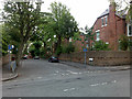
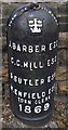
7

Mapperley Road and Redcliffe Road junction
Note the old boundary marker http://www.geograph.org.uk/photo/3903443 at the apex of the junction. The postbox appears in close up here http://www.geograph.org.uk/photo/3903444
Image: © Alan Murray-Rust
Taken: 18 Mar 2014
0.06 miles
8
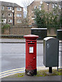
Mapperley Road postbox ref NG3 38
Standard EIIR pillar box. See http://www.geograph.org.uk/photo/3903442 for location.
Image: © Alan Murray-Rust
Taken: 18 Mar 2014
0.06 miles
9

Woodborough Road: Bowers Avenue
Typical three-storey Victorian houses on one of the many steep streets on the hilly eastern side of the city.
Image: © John Sutton
Taken: 23 Jun 2014
0.06 miles
10
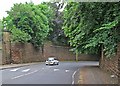
The top of Redcliffe Road
Redcliffe Road drops steeply from Mapperley Road to Mansfield Road and there are huge Bulwell stone retaining walls at the corner near the top end. Alan Murray-Rust's Image] is a view up the hill. The photograph was taken on an especially overcast Sunday morning in June.
Image: © John Sutton
Taken: 15 Jun 2014
0.06 miles