IMAGES TAKEN NEAR TO
Albert Road, Alexandra Park, NOTTINGHAM, NG3 4JD
Introduction
This page details the photographs taken nearby to Albert Road, Alexandra Park, NG3 4JD by members of the Geograph project.
The Geograph project started in 2005 with the aim of publishing, organising and preserving representative images for every square kilometre of Great Britain, Ireland and the Isle of Man.

There are currently over 7.5m images from over14,400 individuals and you can help contribute to the project by visiting https://www.geograph.org.uk
Image Map
Images are licensed for reuse under creativecommons.org/licenses/by-sa/2.0
Notes
- Clicking on the map will re-center to the selected point.
- The higher the marker number, the further away the image location is from the centre of the postcode.
Image Listing (35 Images Found)
Images are licensed for reuse under creativecommons.org/licenses/by-sa/2.0
Image
Details
Distance
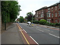
2
No. 418 Woodborough Road at Dagmar Grove junction
There is an Ordnance survey benchmark Image on the wall pier, right hand face, at the corner of the wall
Image: © Luke Shaw
Taken: 8 Mar 2019
0.08 miles
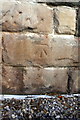
3
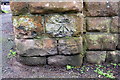
Benchmark on corner pier of wall bounding #418 Woodborough Road
Ordnance Survey documents indicate that in 1962 this cut mark benchmark levelled at 117.351m above Newlyn Datum was present on this pier
Image: © Luke Shaw
Taken: 8 Mar 2019
0.08 miles
4
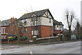
Woodborough Road: a lot of terra cotta
These grand villas on the corner of Dagmar Grove have ornate Romanesque doorways and decorative panels and friezes.
Image: © John Sutton
Taken: 15 Jun 2014
0.08 miles
5
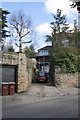
'Riseholme', The Crescent
There is an OS benchmark Image on a stone in the wall to the right of the right hand gatepost
Image: © Roger Templeman
Taken: 31 Mar 2013
0.09 miles
7
Benchmark on wall of 'Riseholme', The Crescent
Ordnance Survey cut mark benchmark described on the Bench Mark Database at http://www.bench-marks.org.uk/bm47882
Image: © Roger Templeman
Taken: 31 Mar 2013
0.10 miles
8
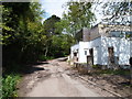
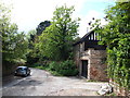
Nottingham - NG3 (Alexandra Park)
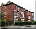
A view of a much more modern house on The Crescent, an unadopted road off Woodborough Road at the side of the Alexandra Court block of flats. In August 1853 John Hine, brother of T.C. Hine, the well-known Nottingham architect, bought Thomas' part of the 27 acres known as "Mapperley Hills Common" with the intention of developing an exclusive residential estate on it. However, it seems that cash flow problems arose and apart from a small number of properties on The Crescent, "Alexandra Park" was never developed as extensively as had been planned. This property appears unfinished and the road is currently in a poor state of repair giving a run down feel to the site. Planning permission exists however, for several modern properties to be built within the grounds of the large house nearest to the Alexandra Court block of flats.
Image: © David Hallam-Jones
Taken: 11 May 2012
0.10 miles
9
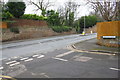
Junction of Woodborough Road and Denmark Grove
Ordnance Survey documents indicate that in 1962 there was a cut mark benchmark levelled at 112.538m above Newlyn Datum on the wall opposite the junction
Image: © Luke Shaw
Taken: 8 Mar 2019
0.10 miles
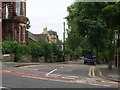
10
Nottingham - NG3 (Alexandra Park)
A stretch of the winding road known as "The Crescent" off Woodborough Road, at the side of the Alexandra Court block of flats. In August 1853 John Hine, the brother of T.C. Hine the well-known Nottingham architect, bought Thomas' part of the 27 acres known as "Mapperley Hills Common" with the intention of developing an exclusive residential estate on it. However, it seems that cash flow problems arose and so, apart from a small number of properties, "Alexandra Park" was never developed as extensively as had been planned. The road is unadopted and currently in a poor state of repair giving a run down feel to the whole site. Planning permission exists however, for several modern properties to be built within the grounds of the large house on this road nearest to Alexandra Court block of flats.
Image: © David Hallam-Jones
Taken: 11 May 2012
0.10 miles