IMAGES TAKEN NEAR TO
Villa Road, NOTTINGHAM, NG3 4GG
Introduction
This page details the photographs taken nearby to Villa Road, NG3 4GG by members of the Geograph project.
The Geograph project started in 2005 with the aim of publishing, organising and preserving representative images for every square kilometre of Great Britain, Ireland and the Isle of Man.

There are currently over 7.5m images from over14,400 individuals and you can help contribute to the project by visiting https://www.geograph.org.uk
Image Map
Images are licensed for reuse under creativecommons.org/licenses/by-sa/2.0
Notes
- Clicking on the map will re-center to the selected point.
- The higher the marker number, the further away the image location is from the centre of the postcode.
Image Listing (334 Images Found)
Images are licensed for reuse under creativecommons.org/licenses/by-sa/2.0
Image
Details
Distance
1
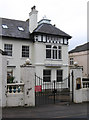
Nottingham - white rendered house on Villa Road
Image: © Dave Bevis
Taken: 25 Feb 2013
0.03 miles
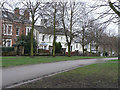
2
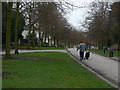
Elm Avenue
Part of a green corridor created probably in the 1870s, stretching from the Arboretum round the north east of the City to St Ann's. Other parts still retain the mature trees planted at the inception, but the age of trees along here suggests that the originals were elms which succumbed to the Dutch Elm Disease disaster of the late 70s.
Image: © Alan Murray-Rust
Taken: 8 Mar 2009
0.04 miles
3
![Elm Avenue [2]](https://s1.geograph.org.uk/geophotos/05/34/97/5349769_e4e2ae61_120x120.jpg)
Elm Avenue [2]
Elm Avenue from Cranmer Street, looking towards Huntingdon Road. This is the reverse view to Image
This delightful traffic-free avenue runs, as Elm Avenue, from Huntingdon Road, A60, to Bellvue Reservoir then as Corporation Oaks and as Robin Hood Chase to St Ann's Well Road.
Image: © Michael Dibb
Taken: 31 Mar 2017
0.04 miles
4
![Elm Avenue [1]](https://s0.geograph.org.uk/geophotos/05/34/97/5349764_5b30e7c5_120x120.jpg)
Elm Avenue [1]
Elm Avenue from Huntingdon Road. This is the reverse view to Image
This delightful traffic-free avenue runs, As Elm Avenue, from Huntingdon Road, A60, to Bellvue Reservoir then as Corporation Oaks and as Robin Hood Chase to St Ann's Well Road.
Image: © Michael Dibb
Taken: 31 Mar 2017
0.04 miles
5
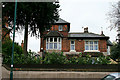
Watson Fothergill alterations
To a house on Mapperley Road. The alterations were done in 1890.
Image: © David Lally
Taken: 6 May 2010
0.05 miles
7
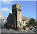
Former Presbyterian Church, Mansfield Road
Built in 1897 to a design by Brewil & Baily, it shows clear influence of the Art Nouveau style. It subsequently became a Christian Science Church and has recently become a Sikh temple.
Image: © Alan Murray-Rust
Taken: 8 Mar 2009
0.06 miles
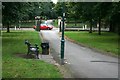
8

Elm Avenue, looking down from Belle Vue reservoir
Looking west across Cranmer Street
Image: © Alan Murray-Rust
Taken: 27 Nov 2022
0.06 miles
9
Villas on Elm Avenue
The houses on the east side of the avenue are generally less pretentious than those on the opposite side.
Image: © Alan Murray-Rust
Taken: 8 Mar 2009
0.06 miles
10
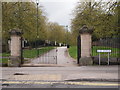
Nottingham - NG1
Looking towards Huntington St, NG1. This is the Elm Avenue/Huntingdon Street section of a longer footpath that runs between the A60 - near to where it enters the city (Huntingdon St) - to Woodborough Road (the B684). Elm Avenue cuts the footpath in half at this point. Together with several other sections this much longer footpath encircles the Bellevue covered-reservoir at its midpoint. Thus, from a hot air balloon an observer would probably notice a rosette-shaped tract of land with the grass-covered reservoir forming the circular part of the rosette with two prominent grass-edged footpaths forming the rosette ribbons.
Image: © David Hallam-Jones
Taken: 20 Apr 2012
0.06 miles