IMAGES TAKEN NEAR TO
Ewerby Thorpe, SLEAFORD, NG34 9PR
Introduction
This page details the photographs taken nearby to NG34 9PR by members of the Geograph project.
The Geograph project started in 2005 with the aim of publishing, organising and preserving representative images for every square kilometre of Great Britain, Ireland and the Isle of Man.

There are currently over 7.5m images from over14,400 individuals and you can help contribute to the project by visiting https://www.geograph.org.uk
Image Map
Images are licensed for reuse under creativecommons.org/licenses/by-sa/2.0
Notes
- Clicking on the map will re-center to the selected point.
- The higher the marker number, the further away the image location is from the centre of the postcode.
Image Listing (13 Images Found)
Images are licensed for reuse under creativecommons.org/licenses/by-sa/2.0
Image
Details
Distance
2
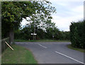
Junction at Ewerby Thorpe
Unnamed road joins Thorpe Lane
Image: © J.Hannan-Briggs
Taken: 21 Aug 2011
0.07 miles
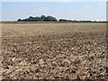
4
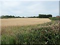
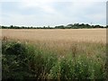
Barley field at Ewerby Thorpe
Surrounded on three side by the road through the hamlet.
Image: © Christine Johnstone
Taken: 14 Aug 2020
0.09 miles
5
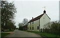
Building at Whitehouse Farm, Ewerby Thorpe
Looking north-west from Ewerby Thorpe Farm.
Image: © Christine Johnstone
Taken: 14 Aug 2020
0.10 miles
6
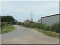
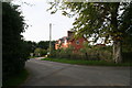
Road entering Ewerby Thorpe from the south
Ewerby Thorpe is a farming hamlet about a mile east of the village of Ewerby.
Image: © Christine Johnstone
Taken: 14 Aug 2020
0.10 miles
8
Ewerby Thorpe
Looking back towards Howell from the only road junction in Ewerby Thorpe.
Image: © Roger May
Taken: 14 Jun 2007
0.11 miles
9
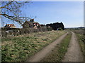
Thorpe House From a Distance
Taken from the public footpath from Ewerby towards the River Slea.
Image: © Ian Paterson
Taken: 7 Sep 2007
0.13 miles
10
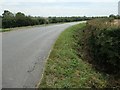
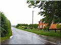
Dry ditch alongside the road to Howell
The flat landscape in this part of Lincolnshire is full of drains.
Image: © Christine Johnstone
Taken: 14 Aug 2020
0.15 miles