IMAGES TAKEN NEAR TO
Park Lane, SLEAFORD, NG34 9PG
Introduction
This page details the photographs taken nearby to Park Lane, NG34 9PG by members of the Geograph project.
The Geograph project started in 2005 with the aim of publishing, organising and preserving representative images for every square kilometre of Great Britain, Ireland and the Isle of Man.

There are currently over 7.5m images from over14,400 individuals and you can help contribute to the project by visiting https://www.geograph.org.uk
Image Map
Images are licensed for reuse under creativecommons.org/licenses/by-sa/2.0
Notes
- Clicking on the map will re-center to the selected point.
- The higher the marker number, the further away the image location is from the centre of the postcode.
Image Listing (5 Images Found)
Images are licensed for reuse under creativecommons.org/licenses/by-sa/2.0
Image
Details
Distance
1
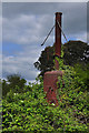
Rusty boiler - Haverholme
The 'boiler' is at the end of a narrow gauge line set on a concrete base. I have no idea as to its purpose but can only imagine that it has been used in some agricultural process or that of gravel extraction given its location in the fenlands adjacent to what is now a carp fishing lake.
Image: © Mick Lobb
Taken: 16 May 2010
0.07 miles
2
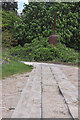
Narrow gauge tracks to boiler - Haverholme
Image: © Mick Lobb
Taken: 16 May 2010
0.08 miles
5
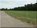
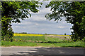
Strip of woodland off Park Lane
Narrow and irregular in shape, the strip of woodland wriggles for about a mile between Evedon Wood and Haverholme Wood.
Image: © Christine Johnstone
Taken: 14 Aug 2020
0.25 miles