IMAGES TAKEN NEAR TO
Papermill Lane, SLEAFORD, NG34 9PD
Introduction
This page details the photographs taken nearby to Papermill Lane, NG34 9PD by members of the Geograph project.
The Geograph project started in 2005 with the aim of publishing, organising and preserving representative images for every square kilometre of Great Britain, Ireland and the Isle of Man.

There are currently over 7.5m images from over14,400 individuals and you can help contribute to the project by visiting https://www.geograph.org.uk
Image Map
Images are licensed for reuse under creativecommons.org/licenses/by-sa/2.0
Notes
- Clicking on the map will re-center to the selected point.
- The higher the marker number, the further away the image location is from the centre of the postcode.
Image Listing (5 Images Found)
Images are licensed for reuse under creativecommons.org/licenses/by-sa/2.0
Image
Details
Distance
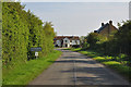
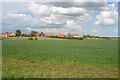
2
Evedon Road
Looking towards Evedon, a commuter village just north east of Sleaford, with a lot of new build and conversions. The square red brick building just to the right of the large tree is a converted water tower.
Image: © Kate Jewell
Taken: 28 Apr 2008
0.15 miles
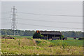
3
Evedon near Sleaford
Evedon sits on a gentle rise at the edge of the Lincolnshire fens.
View from Evedon Road.
Image: © Kate Jewell
Taken: 28 Apr 2008
0.15 miles