IMAGES TAKEN NEAR TO
Lincoln Road, SLEAFORD, NG34 8XY
Introduction
This page details the photographs taken nearby to Lincoln Road, NG34 8XY by members of the Geograph project.
The Geograph project started in 2005 with the aim of publishing, organising and preserving representative images for every square kilometre of Great Britain, Ireland and the Isle of Man.

There are currently over 7.5m images from over14,400 individuals and you can help contribute to the project by visiting https://www.geograph.org.uk
Image Map
Images are licensed for reuse under creativecommons.org/licenses/by-sa/2.0
Notes
- Clicking on the map will re-center to the selected point.
- The higher the marker number, the further away the image location is from the centre of the postcode.
Image Listing (5 Images Found)
Images are licensed for reuse under creativecommons.org/licenses/by-sa/2.0
Image
Details
Distance
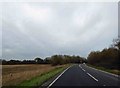
1

A15 to Sleaford and the Sleaford bypass: aerial 2018
Image: © Chris
Taken: 30 Jun 2018
0.09 miles
2
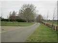
Roadway to Highfield House
The first part of this roadway (as far as the bend) follows the course of the former military railway to Cranwell https://en.wikipedia.org/wiki/Cranwell_branch
Image: © Jonathan Thacker
Taken: 4 Mar 2023
0.18 miles
5
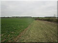
Field edge near Hall Farm. Leasingham
Image: © Jonathan Thacker
Taken: 4 Mar 2023
0.24 miles