IMAGES TAKEN NEAR TO
Swarby, SLEAFORD, NG34 8TF
Introduction
This page details the photographs taken nearby to NG34 8TF by members of the Geograph project.
The Geograph project started in 2005 with the aim of publishing, organising and preserving representative images for every square kilometre of Great Britain, Ireland and the Isle of Man.

There are currently over 7.5m images from over14,400 individuals and you can help contribute to the project by visiting https://www.geograph.org.uk
Image Map
Images are licensed for reuse under creativecommons.org/licenses/by-sa/2.0
Notes
- Clicking on the map will re-center to the selected point.
- The higher the marker number, the further away the image location is from the centre of the postcode.
Image Listing (36 Images Found)
Images are licensed for reuse under creativecommons.org/licenses/by-sa/2.0
Image
Details
Distance
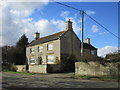
2

Culverthorpe Road into Swarby closed
Openreach engineers were installing fibre optic cable across the road ahead
Image: © Tim Heaton
Taken: 22 Jun 2023
0.02 miles
3
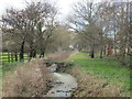
The North Beck at Swarby
Looking upstream.
Image: © Jonathan Thacker
Taken: 2 Mar 2017
0.03 miles
4
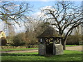
Former well head, The Green, Swarby
A late nineteenth century construction.
Image: © Jonathan Thacker
Taken: 2 Mar 2017
0.03 miles
5
Festive transport "hub"
Ideal transport "hub" for a small settlement - and tastefully decorated too. Anti-covid/delta/omicron measures include lots of fresh air and a physical reminder of what a 2m diameter circle really looks like so you can stay apart the requisite distance.
The only downside is that this is Christmas Day and there's no bus service running.
Image: © Ian Paterson
Taken: 25 Dec 2021
0.03 miles
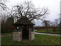
6

Former Well Head
The description comes direct from the Historic England listing. This is a grade II listed structure - https://historicengland.org.uk/listing/the-list/list-entry/1061787
Image: © Bob Harvey
Taken: 16 Jan 2022
0.03 miles
7
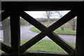
The view from the well-house
Looking out from the Image
Image: © Bob Harvey
Taken: 16 Jan 2022
0.03 miles
8

Old Direction Sign - Signpost by Aunsby Road, Swarby
Ball finial - 3 arms; by the UC road, in parish of Aswarby and Swarby (North Kesteven District), outside parish church, on verge.
Surveyed
Milestone Society National ID: LI_TF0440
Image: © Milestone Society
Taken: Unknown
0.04 miles
9

Village centre
The road-meet in Swarby, with fingerpost and former village pump-house (Image)
Image: © Bob Harvey
Taken: 16 Jan 2022
0.05 miles
10
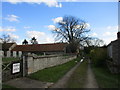
Lane by the churchyard, Swarby
Leads to Church Farm.
Image: © Jonathan Thacker
Taken: 2 Mar 2017
0.05 miles