IMAGES TAKEN NEAR TO
Aswarby, SLEAFORD, NG34 8SG
Introduction
This page details the photographs taken nearby to NG34 8SG by members of the Geograph project.
The Geograph project started in 2005 with the aim of publishing, organising and preserving representative images for every square kilometre of Great Britain, Ireland and the Isle of Man.

There are currently over 7.5m images from over14,400 individuals and you can help contribute to the project by visiting https://www.geograph.org.uk
Image Map
Images are licensed for reuse under creativecommons.org/licenses/by-sa/2.0
Notes
- Clicking on the map will re-center to the selected point.
- The higher the marker number, the further away the image location is from the centre of the postcode.
Image Listing (9 Images Found)
Images are licensed for reuse under creativecommons.org/licenses/by-sa/2.0
Image
Details
Distance
2
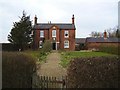
Elms Farm House
See also Thorns Farm in the next square east. An identical building dated 1852. Even the outbuilding to the right looks the same.
Image: © Ken Brockway
Taken: 10 Mar 2007
0.07 miles
3
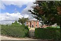
The Elms
Listed grade II. Built in 1848 for the Whichcote family of Aswarby Park https://historicengland.org.uk/listing/the-list/list-entry/1061785?section=official-list-entry . An identical building to Image
Image: © Tim Heaton
Taken: 29 Jul 2023
0.08 miles
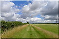
4
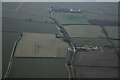
Ridge and Furrow on field east of Aswarby: aerial 2022
Image: © Chris
Taken: 23 Jan 2022
0.11 miles
6
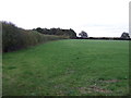
Farmland towards Forty Acre Plantation
Near Thorns Farm.
Image: © JThomas
Taken: 26 Oct 2013
0.18 miles
8
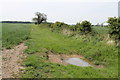
Farm track and drain
There is still a puddle from recent rain.
Image: © J.Hannan-Briggs
Taken: 26 May 2013
0.23 miles
9
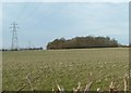
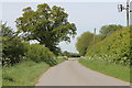
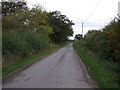
Power marches past peace
Unfeeling pylons feed power past a small coppice at rest in the March sunshine east of Aswarby
Image: © Donnylad
Taken: 10 Mar 2007
0.24 miles