IMAGES TAKEN NEAR TO
Silk Willoughby, SLEAFORD, NG34 8RU
Introduction
This page details the photographs taken nearby to NG34 8RU by members of the Geograph project.
The Geograph project started in 2005 with the aim of publishing, organising and preserving representative images for every square kilometre of Great Britain, Ireland and the Isle of Man.

There are currently over 7.5m images from over14,400 individuals and you can help contribute to the project by visiting https://www.geograph.org.uk
Image Map
Images are licensed for reuse under creativecommons.org/licenses/by-sa/2.0
Notes
- Clicking on the map will re-center to the selected point.
- The higher the marker number, the further away the image location is from the centre of the postcode.
Image Listing (11 Images Found)
Images are licensed for reuse under creativecommons.org/licenses/by-sa/2.0
Image
Details
Distance
1
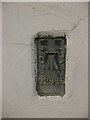
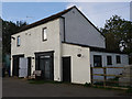
Flush Bracket OSBM G2855: Southview Farm
Flush bracket benchmark on a building at Southview Farm, now riding stables. See http://www.geograph.org.uk/photo/5940065 for a wider view and https://www.bench-marks.org.uk/bm13677 for details.
Image: © Brian Westlake
Taken: 11 Oct 2018
0.01 miles
2
Building at Southview Farm Riding Stables
There is a flush bracket benchmark on this building at Southview Farm, now riding stables. See http://www.geograph.org.uk/photo/5940061 for a closer view and https://www.bench-marks.org.uk/bm13677 for details.
Image: © Brian Westlake
Taken: 11 Oct 2018
0.01 miles
3
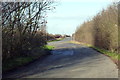
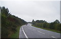
Layby on the A15 near Silk Willoughby
Formed from a bend improvement scheme.
Image: © Alan Murray-Rust
Taken: 24 Dec 2014
0.09 miles
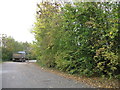
6
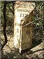
Old Milestone, on the A15, London Road 112
Opposite and just S of lay-by (N of parish boundary). Located on the West side of road, in copse. Cast iron post, London Road iron casting design, erected by Lincoln, SE & SW District turnpike trust, 19th century.
Inscription reads: // SLEAFᴰ. / 3 //FALKᴹ. / 6 //SILK / WILLOUGHBY / PARISH / LONDON / 112
Grade II listed by Historic England.
Milestone Society National ID: LI_LO112
Image: © Milestone Society
Taken: Unknown
0.16 miles
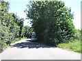
7
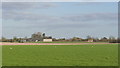
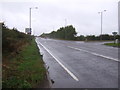
View towards Silk Willoughby
From the A15. The spire of the church is just visible.
Image: © Alan Murray-Rust
Taken: 24 Dec 2014
0.17 miles