IMAGES TAKEN NEAR TO
Roxholm, SLEAFORD, NG34 8NF
Introduction
This page details the photographs taken nearby to NG34 8NF by members of the Geograph project.
The Geograph project started in 2005 with the aim of publishing, organising and preserving representative images for every square kilometre of Great Britain, Ireland and the Isle of Man.

There are currently over 7.5m images from over14,400 individuals and you can help contribute to the project by visiting https://www.geograph.org.uk
Image Map
Images are licensed for reuse under creativecommons.org/licenses/by-sa/2.0
Notes
- Clicking on the map will re-center to the selected point.
- The higher the marker number, the further away the image location is from the centre of the postcode.
Image Listing (6 Images Found)
Images are licensed for reuse under creativecommons.org/licenses/by-sa/2.0
Image
Details
Distance
1
Small Church and Graveyard Roxholme near Leasingham
There is no sign on this Church but it is still in use
Image: © Ian Paterson
Taken: 20 Apr 2007
0.02 miles
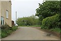
2
House beside Church on Leasingham / Bloxholme Road
Image: © Ian Paterson
Taken: 20 Apr 2007
0.02 miles
3
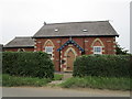
Former Methodist church, Roxholme
Now a dwelling.
Image: © Jonathan Thacker
Taken: 24 Jun 2019
0.03 miles
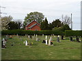
4
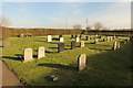
Roxholm cemetery
Cemetery by the former Roxholm Chapel, the chapel opened in 1871, closed in 2005 and is now a private house.
Image: © Richard Croft
Taken: 2 Apr 2015
0.06 miles