IMAGES TAKEN NEAR TO
The Maltings, SLEAFORD, NG34 8GQ
Introduction
This page details the photographs taken nearby to The Maltings, NG34 8GQ by members of the Geograph project.
The Geograph project started in 2005 with the aim of publishing, organising and preserving representative images for every square kilometre of Great Britain, Ireland and the Isle of Man.

There are currently over 7.5m images from over14,400 individuals and you can help contribute to the project by visiting https://www.geograph.org.uk
Image Map
Images are licensed for reuse under creativecommons.org/licenses/by-sa/2.0
Notes
- Clicking on the map will re-center to the selected point.
- The higher the marker number, the further away the image location is from the centre of the postcode.
Image Listing (13 Images Found)
Images are licensed for reuse under creativecommons.org/licenses/by-sa/2.0
Image
Details
Distance
3
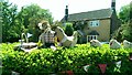
Chicken and a basket
One of the entries in the Leasingham and Roxholm Scarecrow Festival, possibly the prizewinner judging by the little flag in the basket beside the eggs.
Image: © Ian Paterson
Taken: 28 May 2020
0.10 miles
7
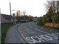
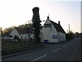
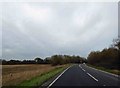
Lincoln Road, Leasingham
This used to be the main road from Sleaford to Lincoln, but the village is now bypassed.
Image: © Alan Murray-Rust
Taken: 20 Dec 2009
0.16 miles
9
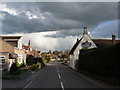
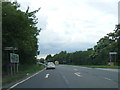
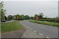
Lincoln Road to Captain's Hill
Looking downhill from beside the Duke of Wellington pub. The spire of St Andrew's Church Image is visible in the background.
Image: © Ian Paterson
Taken: 10 Apr 2012
0.20 miles