1
Houses at junction in Hood Close
#24 at the corner
Image: © Luke Shaw
Taken: 27 Jun 2023
0.05 miles
2
Electricity substation on north side of Grantham Lane opposite Northfield Road
Ordnance Survey documents indicate that a benchmark was levelled at 29.780m above Newlyn Datum in 1955 on a telephone exchange, the rendered building behind the substation
Image: © Roger Templeman
Taken: 27 Jun 2023
0.07 miles
3
Milepost on Grantham Road
A well looked after cast iron example.
Image: © Alan Murray-Rust
Taken: 24 Dec 2014
0.08 miles
4
Milepost
Old milepost at Sleaford, Lincolnshire. For close up view see http://www.geograph.org.uk/photo/2869410
Image: © Keith Evans
Taken: 24 Mar 2012
0.09 miles
5
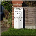
Old Milestone, on the B1517, Quarrington
By No. 236 Grantham Road, located on the North side of road, on the verge. Cast iron post, Hornsby iron casting design, erected by an unknown authority, 19th century. Alternative views see http://www.geograph.org.uk/photo/6675759 & http://www.geograph.org.uk/photo/2869422 & http://www.geograph.org.uk/photo/2155790 & http://www.geograph.org.uk/photo/2869410
Inscription reads: // SLEAFᴰ. / 1 //ANCASᴿ. / 5 //QUARRINGTON / PARISH / GRANTHAM / 13
Milestone Society National ID: LI_SLAN01 Alternative views see http://www.geograph.org.uk/photo/6675759 & http://www.geograph.org.uk/photo/2869422 & http://www.geograph.org.uk/photo/2155790 & http://www.geograph.org.uk/photo/2869410
Image: © Milestone Society
Taken: Unknown
0.09 miles
6
Winter sunset on Grantham Road, Quarrington
Image: © Mick Lobb
Taken: 24 Jan 2009
0.10 miles
7
Quarrington milepost
Milepost on Grantham Road http://www.geograph.org.uk/photo/2155783
Sleaford 1
Ancaster 5
Image: © Richard Croft
Taken: 11 Nov 2010
0.10 miles
8
Old Milepost
Old milepost at Sleaford, Lincolnshire. For overall view see http://www.geograph.org.uk/photo/2869422
Image: © Keith Evans
Taken: 24 Mar 2012
0.10 miles
9
Milestone, Grantham Rd, Sleaford
On the North Eastern side of the road.
Quarrintoₙ / Parish / Grantham 13 / Sleafᴰ 1 / Ancasᴿ 5
Milestone Society National ID: LI_SLAN01
Image: © Graham Munday
Taken: 14 Nov 2020
0.10 miles
10
Grantham Road, looking towards the town
There is an old cast-iron milepost http://www.geograph.org.uk/photo/4291182 on the left.
Image: © Alan Murray-Rust
Taken: 24 Dec 2014
0.11 miles


