IMAGES TAKEN NEAR TO
Carre Street, SLEAFORD, NG34 7TW
Introduction
This page details the photographs taken nearby to Carre Street, NG34 7TW by members of the Geograph project.
The Geograph project started in 2005 with the aim of publishing, organising and preserving representative images for every square kilometre of Great Britain, Ireland and the Isle of Man.

There are currently over 7.5m images from over14,400 individuals and you can help contribute to the project by visiting https://www.geograph.org.uk
Image Map
Images are licensed for reuse under creativecommons.org/licenses/by-sa/2.0
Notes
- Clicking on the map will re-center to the selected point.
- The higher the marker number, the further away the image location is from the centre of the postcode.
Image Listing (591 Images Found)
Images are licensed for reuse under creativecommons.org/licenses/by-sa/2.0
Image
Details
Distance
1
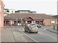
The Barge & Bottle, Sleaford
The upper floor windows of The Hub centre can be seen above the single storeyed structure of the pub and restaurant.
Image: © Mick Lobb
Taken: 24 Jan 2009
0.01 miles
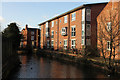
3
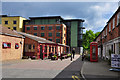
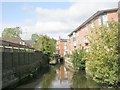
Navigation Wharf on the River Slea - Sleaford
Development of the wharf area with shops, a pub and The Hub arts centre.
Image: © Mick Lobb
Taken: 17 May 2010
0.01 miles
4
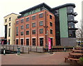
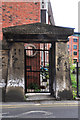
Carre Street Vicinity, Sleaford, Lincs.
The west side of The Hub, the National Centre for Craft and Design building on Navigation Wharf. It is housed in a former seed warehouse. The original seed business was founded by James Hubbard in 1880 and the company eventually became the largest supplier of marrowfat peas in the country. The present building dates from 1938 but in 2004 it was converted into an ultra-modern art and craft gallery with 1,000 square metres of exhibition space, craft workshops, a shop and café. The rooftop gallery and veranda provide some excellent views. "The Navigation" continues to the left (under the footbridge) passing through the town centre as far as Castle Causeway.
Image: © David Hallam-Jones
Taken: 29 Nov 2014
0.01 miles
5
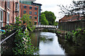
Arthur's Court
Apartments by the River Slea at Navigation Wharf
Image: © Richard Croft
Taken: 23 Jan 2014
0.01 miles
6
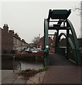
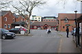
New Street Vicinity, Sleaford, Lincs.
The wider footpath element of this replacement bridge (2008) allows wheelchair and mobility scooter users and people with prams to cross it more easily. Most significantly of all - perhaps - is that boat users can travel through Sleaford as far as Castle Causeway. This £150,000 bridge replaced the former fixed footbridge that stopped most traffic, apart from canoes, from proceeding any further. A lift-up section is operated manually by boat-users as required. needed. New Street is seen ahead.
Image: © David Hallam-Jones
Taken: 29 Nov 2014
0.02 miles
7
Navigation Wharf on the River Slea - Sleaford
The industrial past replaced by modern apartments, shopping precinct and an arts centre.
Image: © Mick Lobb
Taken: 17 May 2010
0.02 miles
9
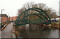
New Street Vicinity, Sleaford, Lincs.
Boat users wishing to travel through Sleaford are able to benefit from this new £150,000 bridge that was installed in 2008. It replaced the former fixed footbridge that stopped most traffic – apart from canoes – from proceeding any further. The lift-up section is operated manually by the user when needed. The footpath element of the bridge is also wider, allowing wheelchair users, and people pushing prams, to cross more easily. A new river access point has also been created with the construction of the new slipway near The National Centre for Craft and Design building up ahead. Carre Street and the town centre lie ahead and New Street is reached via a ramp or steps on the left.
Image: © David Hallam-Jones
Taken: 29 Nov 2014
0.02 miles