IMAGES TAKEN NEAR TO
East Banks, SLEAFORD, NG34 7TL
Introduction
This page details the photographs taken nearby to East Banks, NG34 7TL by members of the Geograph project.
The Geograph project started in 2005 with the aim of publishing, organising and preserving representative images for every square kilometre of Great Britain, Ireland and the Isle of Man.

There are currently over 7.5m images from over14,400 individuals and you can help contribute to the project by visiting https://www.geograph.org.uk
Image Map
Images are licensed for reuse under creativecommons.org/licenses/by-sa/2.0
Notes
- Clicking on the map will re-center to the selected point.
- The higher the marker number, the further away the image location is from the centre of the postcode.
Image Listing (584 Images Found)
Images are licensed for reuse under creativecommons.org/licenses/by-sa/2.0
Image
Details
Distance
1
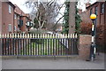
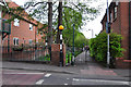
Former Canal
There are two bridges in Carre Street, with the same stylish arrow-headed railings. One is across the River Slea, the other over the former route of the canal to the town basin in what is now the Money's Yard car park. This is the route of the canal.
Image: © Bob Harvey
Taken: 23 Mar 2018
0.01 miles
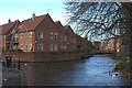
2
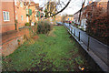
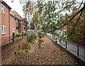
East Banks
Former spur of the Sleaford Navigation, with new properties on the left on the site of former wharfage.
Image: © Richard Croft
Taken: 23 Jan 2014
0.01 miles
3
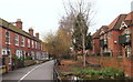
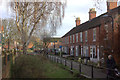
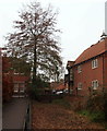
Carre Street Vicinity, Sleaford, Lincs.
Both "Berkeley Court" apartments on the right and this row of terraced houses look out onto this dry, disused spur of the Sleaford Navigation (a canal) that once continued to Money's Corn Mill in the town centre, several hundred metres ahead. Behind the photographer the footpath carries pedestrians towards the new-ish (2008) 'lift-up' bridge and to facilities on the other side of "The Navigation", including the National Centre for Craft and Design, a Health Centre and other parts of the town.
Image: © David Hallam-Jones
Taken: 29 Nov 2014
0.01 miles
6
Carre Street Vicinity, Sleaford, Lincs.
"Berkeley Court" apartments on the right and this row of terraced houses look out onto this dry, disused spur of the Sleaford Navigation (a canal) that once continued to Money's Corn Mill in the town centre, several hundred metres ahead. Behind the photographer the footpath carries pedestrians towards the new-ish (2008) 'lift-up' bridge and to facilities on the other side of "The Navigation", including the National Centre for Craft and Design, a Health Centre and other parts of the town.
Image: © David Hallam-Jones
Taken: 29 Nov 2014
0.01 miles
7
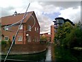
View eastwards from Carr Street
Looking towards the River Slea. The old basin is on the left.
Image: © Robert Eva
Taken: 15 Jan 2020
0.01 miles
8
River, Sculpture, Housing and Arts Centre
The River Slea takes a turn past these retirement homes.
The sculpture is by Will Lasdun (http://www.williamlasdun.com/ ).
The Arts Centre is "The Hub" http://www.thehubcentre.org.
Image: © Ian Paterson
Taken: 30 Aug 2007
0.02 miles
9
River Slea at Carre St basin
The basin is on the left. It is mostly silted up now.
Image: © Robert Eva
Taken: 15 Jan 2020
0.02 miles
10
Carre Street Vicinity, Sleaford, Lincs.
Some of the windows in these "Berkeley Court" apartments on the right of this picture look down onto this dry, disused spur of the Sleaford Navigation (a canal) that once continued to Money's Corn Mill in the town centre, several hundred metres beyond the railings. Behind the photographer, as well as serving a row of terraced houses that also face this spur, the footpath carries pedestrians towards the new-ish (2008) 'lift-up' bridge and to facilities on the other side of "The Navigation", including the National Centre for Craft and Design.
Image: © David Hallam-Jones
Taken: 29 Nov 2014
0.02 miles