IMAGES TAKEN NEAR TO
Carre Street, SLEAFORD, NG34 7TG
Introduction
This page details the photographs taken nearby to Carre Street, NG34 7TG by members of the Geograph project.
The Geograph project started in 2005 with the aim of publishing, organising and preserving representative images for every square kilometre of Great Britain, Ireland and the Isle of Man.

There are currently over 7.5m images from over14,400 individuals and you can help contribute to the project by visiting https://www.geograph.org.uk
Image Map
Images are licensed for reuse under creativecommons.org/licenses/by-sa/2.0
Notes
- Clicking on the map will re-center to the selected point.
- The higher the marker number, the further away the image location is from the centre of the postcode.
Image Listing (569 Images Found)
Images are licensed for reuse under creativecommons.org/licenses/by-sa/2.0
Image
Details
Distance
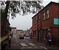
1
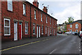
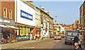
Handley Street - Sleaford
Terraced housing off the main street through the town.
Image: © Mick Lobb
Taken: 17 May 2010
0.02 miles
2
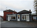
Hair and beauty salon, Handley Street
Image: © Jonathan Thacker
Taken: 20 Oct 2017
0.02 miles
3
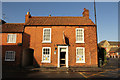
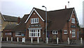
41 Boston Road
Grade II listed, early 19th century house on Boston Road
Image: © Richard Croft
Taken: 23 Jan 2014
0.02 miles
4
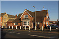
The White Horse
Hostelry on Carre Street in Sleaford
Image: © Richard Croft
Taken: 23 Jan 2014
0.03 miles
5
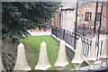
Former canal
The railings give it away - the foreground railings are on the former bridge over the canal at Carre Street.
Image: © Bob Harvey
Taken: 23 Mar 2018
0.04 miles
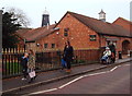
7
White Horse, Carr Street
At the junction with Boston Road.
Image: © Robert Eva
Taken: 15 Jan 2020
0.04 miles
8
Sleaford: NW on South Gate, 1983
Cf. Image]: Not a lot of change in 25 years, except of course people were much smarter.
Image: © Ben Brooksbank
Taken: 25 Aug 1983
0.04 miles
9
Carre Street, Sleaford, Lincs.
In the distance is the main junction of Carre Street with Boston Road. Here however, a road bridge carries Carre Street and a zebra crossing over the dry, non-navigable spur of the Sleaford Navigation (a canal). Blue 'finger signs' point pedestrians in the direction of The National Centre for Craft and Design, a Health Centre and the local leisure centre. The same footpath also leads to Cogglesford Mill Lock. The Carre Street Complementary Medicine and Well-Being Clinic on the right is housed in a building dated 1889.
Image: © David Hallam-Jones
Taken: 29 Nov 2014
0.04 miles
10
Carre Street, Sleaford, Lincs.
This road bridge carries Carre Street over the dry, non-navigable spur of the Sleaford Navigation (a canal) that ends here abruptly where this restaurant has created an outdoor dining area. Behind the photographer blue 'finger signs' at the entrance and/or exit of a footpath point pedestrians in the direction of various local leisure-related amenities. The same footpath also leads to Cogglesford Mill Lock. Money's Mill, a former windmill situated in Money's Yard Car Park, is also visible. It was built c.1796 to capitalise upon the existence of the new canal that allowed for corn to be off-loaded from barges at the foot of it.
Image: © David Hallam-Jones
Taken: 29 Nov 2014
0.04 miles