IMAGES TAKEN NEAR TO
Jermyn Street, SLEAFORD, NG34 7RS
Introduction
This page details the photographs taken nearby to Jermyn Street, NG34 7RS by members of the Geograph project.
The Geograph project started in 2005 with the aim of publishing, organising and preserving representative images for every square kilometre of Great Britain, Ireland and the Isle of Man.

There are currently over 7.5m images from over14,400 individuals and you can help contribute to the project by visiting https://www.geograph.org.uk
Image Map
Images are licensed for reuse under creativecommons.org/licenses/by-sa/2.0
Notes
- Clicking on the map will re-center to the selected point.
- The higher the marker number, the further away the image location is from the centre of the postcode.
Image Listing (546 Images Found)
Images are licensed for reuse under creativecommons.org/licenses/by-sa/2.0
Image
Details
Distance
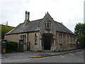
1
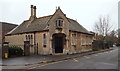
Jermyn Street, Sleaford, Lincs.
This former school annexe to Kesteven and Sleaford High School may have been designed by the S.G Parry of London (1878-1924) & Wm. Kirk of Nottingham (1749-1823) partnership c1870. "Kirk and Parry of Jermyn Street" are listed in directories from the mid C19th and Kirk & Parry also designed a flour mill off Jermyn Street. There is some suggestion therefore that this particular building may have served as the ‘local’ office for their architectural work. Now in use as offices, this Grade II-listed building occupies a lodge house location/position adjacent to the entrance to this particular High School behind it. The closed end of the cul-de-sac (ahead) is predominantly residential, whereas the town centre lies behind the photographer.
Image: © David Hallam-Jones
Taken: 29 Nov 2014
0.03 miles
2
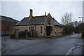
Former schoolroom
Possibly originally the architects office for the constructors, Kirk and Parry
a grade II listed building https://historicengland.org.uk/listing/the-list/list-entry/1261296
Image: © Bob Harvey
Taken: 10 Feb 2018
0.03 miles
3
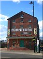
Warehouse near Sleaford station
Just north of Sleaford station, and now apparently a retail furniture warehouse. The awning is curious - being in a style normally seen around 19th century railway buildings. Quite nice red brick, but not in the same class as the great Bass Maltings nearby Image
Image: © Stefan Czapski
Taken: 30 Mar 2008
0.03 miles
5
Former office, Jermyn Street, Sleaford
The office of Kirk and Parry, architects https://en.wikipedia.org/wiki/Kirk_and_Parry Dates from about 1870 https://historicengland.org.uk/listing/the-list/list-entry/1261296?section=official-list-entry
Image: © Jonathan Thacker
Taken: 12 Sep 2024
0.04 miles
6
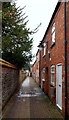
Nag's Head Passage, Sleaford, Lincs.
Less than half-a-minute's walk behind the photographer another footpath (with the same name or maybe a different one?) heads off at a right angle towards the station (barely a minute's walk away). This is an easterly view of the passageway exiting in the town centre. Presumably the passageway took its name from a nearby (former) Grade II-listed public house on South Gate. By all accounts this passageway had been allowed to get into a very run down state around 2008, but with Civic Heritage support, it now provides an interesting shortcut from the south of the town into the town centre and some small but desirable houses.
Image: © David Hallam-Jones
Taken: 29 Nov 2014
0.04 miles
7
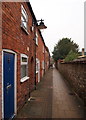
Nag's Head Passage, Sleaford, Lincs.
Another half-a-minute's walk ahead sees another path (with the same name or maybe a different one?) turning left at a right angle towards the station. The
latter is barely another minute's walk away. This is an westerly view of this passageway that presumably took its name from a nearby Grade II-listed former public house on South Gate (i.e. the town centre). By all accounts this passageway had been allowed to get into a very run down state around 2008 but as a result of Civic Heritage support it now provides an interesting shortcut from the south of the town into the town centre and some small desirable houses.
Image: © David Hallam-Jones
Taken: 29 Nov 2014
0.04 miles
8
Jermyn Street, Sleaford, Lincs.
This former school annexe to Kesteven and Sleaford High School may have been designed by the S.G Parry of London (1878-1924) & Wm. Kirk of Nottingham (1749-1823) partnership c1870. "Kirk and Parry of Jermyn Street" are listed in directories from the mid C19th and Kirk & Parry also designed a flour mill off Jermyn Street. There is some suggestion therefore that this particular building may have served as the ‘local’ office for their architectural work. Now in use as offices, this Grade II-listed occupies a lodge house location/position adjacent to the entrance to this particular High School situated seen behind it.
Image: © David Hallam-Jones
Taken: 29 Nov 2014
0.04 miles
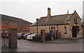
9
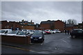
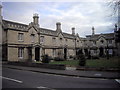
Private car park
A car park operated by a private property company, on a "short-stay" basis. This land was once the horse yard of the Black Bull pub (currently known as the Bull and dog) one of the older Inns in Sleaford.
Image: © Bob Harvey
Taken: 10 Feb 2018
0.04 miles
10
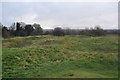
Sleaford Castle
I think the rough site of the keep, certainly in the inner bailey.
Image: © Ashley Dace
Taken: 21 Nov 2010
0.05 miles