IMAGES TAKEN NEAR TO
Riverside Close, SLEAFORD, NG34 7RF
Introduction
This page details the photographs taken nearby to Riverside Close, NG34 7RF by members of the Geograph project.
The Geograph project started in 2005 with the aim of publishing, organising and preserving representative images for every square kilometre of Great Britain, Ireland and the Isle of Man.

There are currently over 7.5m images from over14,400 individuals and you can help contribute to the project by visiting https://www.geograph.org.uk
Image Map
Images are licensed for reuse under creativecommons.org/licenses/by-sa/2.0
Notes
- Clicking on the map will re-center to the selected point.
- The higher the marker number, the further away the image location is from the centre of the postcode.
Image Listing (552 Images Found)
Images are licensed for reuse under creativecommons.org/licenses/by-sa/2.0
Image
Details
Distance
1
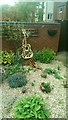
How to Make Music....
Simple. Buy a packet of guitar seeds, grow under glass at minimum 20 degrees and prick out into a large pot filled with well-rotted compost until it's 6 inches tall. Plant on in its permanent position in well-drained soil amongst other plants, ideally with a gravel mulch. As soon as the first fruits start to appear (in around 20 years) cut back all but the best one and eventually you will be rewarded with a fine specimen.
Unfortunately for this gardener, he didn't do enough "Bert" (Weedon) and as a result an infestation of minimitis occurred and is now sadly peppered with the wee beasties' characteristic flight holes.
Image: © Ian Paterson
Taken: 18 May 2020
0.01 miles
2
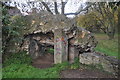
Sleaford Castle
All that remains of the castle, once an impressive stone structure.
http://www.sleaford.gov.uk/castle.html
Image: © Ashley Dace
Taken: 21 Nov 2010
0.04 miles
3
Sleaford Castle
All that remains of the castle, once an impressive stone structure.
http://www.sleaford.gov.uk/castle.html
Image: © Ashley Dace
Taken: 21 Nov 2010
0.04 miles
4
Sleaford Castle - Gatehouse
Noting but earthworks now but this was the gatehouse.
http://www.sleaford.gov.uk/castle.html
Image: © Ashley Dace
Taken: 21 Nov 2010
0.05 miles
5
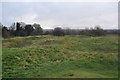
Sleaford Castle
I think the rough site of the keep, certainly in the inner bailey.
Image: © Ashley Dace
Taken: 21 Nov 2010
0.05 miles
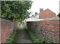
7
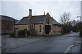
Former office, Jermyn Street, Sleaford
The office of Kirk and Parry, architects https://en.wikipedia.org/wiki/Kirk_and_Parry Dates from about 1870 https://historicengland.org.uk/listing/the-list/list-entry/1261296?section=official-list-entry
Image: © Jonathan Thacker
Taken: 12 Sep 2024
0.06 miles
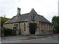
8
Jermyn Street, Sleaford, Lincs.
This former school annexe to Kesteven and Sleaford High School may have been designed by the S.G Parry of London (1878-1924) & Wm. Kirk of Nottingham (1749-1823) partnership c1870. "Kirk and Parry of Jermyn Street" are listed in directories from the mid C19th and Kirk & Parry also designed a flour mill off Jermyn Street. There is some suggestion therefore that this particular building may have served as the ‘local’ office for their architectural work. Now in use as offices, this Grade II-listed building occupies a lodge house location/position adjacent to the entrance to this particular High School behind it. The closed end of the cul-de-sac (ahead) is predominantly residential, whereas the town centre lies behind the photographer.
Image: © David Hallam-Jones
Taken: 29 Nov 2014
0.06 miles
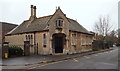
9
Former schoolroom
Possibly originally the architects office for the constructors, Kirk and Parry
a grade II listed building https://historicengland.org.uk/listing/the-list/list-entry/1261296
Image: © Bob Harvey
Taken: 10 Feb 2018
0.06 miles
10
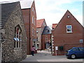
New Shops and Flats
Forming a new link between Southgate and Westgate.
Image: © Ian Paterson
Taken: 1 Aug 2007
0.07 miles