IMAGES TAKEN NEAR TO
Alexandra Road, SLEAFORD, NG34 7QW
Introduction
This page details the photographs taken nearby to Alexandra Road, NG34 7QW by members of the Geograph project.
The Geograph project started in 2005 with the aim of publishing, organising and preserving representative images for every square kilometre of Great Britain, Ireland and the Isle of Man.

There are currently over 7.5m images from over14,400 individuals and you can help contribute to the project by visiting https://www.geograph.org.uk
Image Map
Images are licensed for reuse under creativecommons.org/licenses/by-sa/2.0
Notes
- Clicking on the map will re-center to the selected point.
- The higher the marker number, the further away the image location is from the centre of the postcode.
Image Listing (52 Images Found)
Images are licensed for reuse under creativecommons.org/licenses/by-sa/2.0
Image
Details
Distance
1
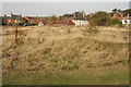
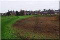
Sleaford Castle site
Grassy mounds and hollows marking the site of Sleaford Castle
Image: © Richard Croft
Taken: 24 Oct 2011
0.09 miles
2
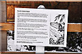
Rauceby Banks information sign - Sleaford
Image: © Mick Lobb
Taken: 23 Dec 2009
0.09 miles
3
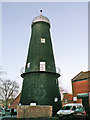
Money's Mill, Sleaford
Since vacated by the Tourist Office the lower two floors were in use as a coffee bar/cafe.
Image: © Mick Lobb
Taken: 3 Dec 2008
0.09 miles
4
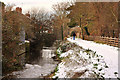
Rauceby Banks on the River Slea - Sleaford
Image: © Mick Lobb
Taken: 23 Dec 2009
0.10 miles
5
Sleaford Castle
Grassy earthworks are pretty much all that remains of this once impressive site. Disappointingly, there are no interpretation boards here for visitors.
Image: © Stephen McKay
Taken: 13 Dec 2015
0.10 miles
6
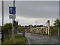
Sleaford West level crossing
This retains a fine set of traditional gates, still with a cast iron gatepost supporting the near gate. The combination of 3 railway tracks and the narrow road means that there are gates on one side of the road only.
Image: © Alan Murray-Rust
Taken: 5 Aug 2012
0.10 miles
7
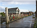
Sleaford West level crossing and signal box
The crossing retains its fine set of traditional gates. The large signal box controlled sidings at the west end of the station as well as the junction of the lines to Lincoln and Grantham.
Image: © Alan Murray-Rust
Taken: 5 Aug 2012
0.10 miles
8
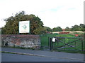
Castlefield, Sleaford
Entrance to the site of Sleaford Castle, on Castle Causeway.
Image: © Malc McDonald
Taken: 11 Sep 2010
0.11 miles
9
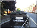
River Slea at Sleaford
The River Slea running alongside West Banks in Sleaford.
Image: © Malc McDonald
Taken: 11 Sep 2010
0.11 miles
