IMAGES TAKEN NEAR TO
Slea Cottages, SLEAFORD, NG34 7PY
Introduction
This page details the photographs taken nearby to Slea Cottages, NG34 7PY by members of the Geograph project.
The Geograph project started in 2005 with the aim of publishing, organising and preserving representative images for every square kilometre of Great Britain, Ireland and the Isle of Man.

There are currently over 7.5m images from over14,400 individuals and you can help contribute to the project by visiting https://www.geograph.org.uk
Image Map
Images are licensed for reuse under creativecommons.org/licenses/by-sa/2.0
Notes
- Clicking on the map will re-center to the selected point.
- The higher the marker number, the further away the image location is from the centre of the postcode.
Image Listing (572 Images Found)
Images are licensed for reuse under creativecommons.org/licenses/by-sa/2.0
Image
Details
Distance
1
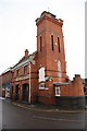
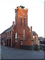
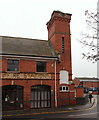
The Old Fire Station
The former Fire Station on Watergate in Sleaford
Image: © Richard Croft
Taken: 6 Feb 2009
0.01 miles
2
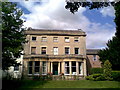
Westgate House, Westgate
Currently home to mri Software LLC, formerly known as Qube Global Software, formerly known as Estate Computer Systems https://www.mrisoftware.com/uk/.
Previously home of the Water Board.
Image: © Ian Paterson
Taken: 30 Aug 2007
0.02 miles
3
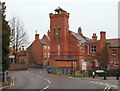
Former Fire Station, Sleaford, Lincs.
West Banks (the road name) joins - or becomes - Water Gate (a road name) here with the restricted entrance to the Riverside shopping complex on the right, the open-gated entrance to the NHS Riversdale Health Clinic on the left and the tower of the former fire station overlooking the junction. A water mill previously stood where this building now stands. The complex now houses offices but date stones on the site bear the dates of the construction of the original fire station building, i.e. 1829 and this building, 1900.
Image: © David Hallam-Jones
Taken: 29 Nov 2014
0.03 miles
4
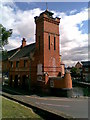
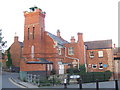
Old Fire Station, Westgate
Fine building on a great site next to the River Slea. Currently home to Dexter and Sharpe http://www.dextersharpe.co.uk/. You can just make out the 'Fire Station' carved solidly into the sandstone lintel to the left of the tower.
Image: © Ian Paterson
Taken: 30 Aug 2007
0.03 miles
5

Family group
One of several duck families to be found on the River Slea. This group posed on the slipway beside the old Fire Station in Westgate, visible in the bottom left corner of this photo Image
Image: © Ian Paterson
Taken: 18 Apr 2009
0.03 miles
6
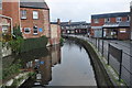
Sleaford, Lincolnshire
One of many water channels running through the town. A few shops to the right.
Image: © Ashley Dace
Taken: 21 Nov 2010
0.03 miles
7
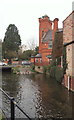
Old fire station, Sleaford
The old fire station building on Watergate, Sleaford. The River Slea flows along the channel to the right of the building.
Image: © Malc McDonald
Taken: 11 Sep 2010
0.03 miles
8
Old fire station, Sleaford
The old fire station on Watergate, Sleaford. The River Slea flows along the channel in the foreground.
Image: © Malc McDonald
Taken: 11 Sep 2010
0.03 miles
9
River Slea, Sleaford, Lincs.
Water Gate ahead, from the Riverside Shopping Centre. The former fire station dominates the point where Water Gate becomes West Banks (another road name). A water mill previously stood where this building now stands. The complex now houses offices but date stones on the site bear the dates of the construction of the original fire station building, i.e. 1829 and this building, 1900. The driveway entrance to the Riversdale Health Clinic is situated beyond the old fire station.
Image: © David Hallam-Jones
Taken: 29 Nov 2014
0.03 miles
10
Water Gate, Sleaford, Lincs.
The entrance to the Riverside shopping complex is visible on the right on this former fire station building. Over the railings that the pedestrian is passing is a section of the River Slea. A water mill previously stood where this building now stands. The complex currently houses offices but date stones on the site bear the dates of the construction of the original fire station building, i.e. 1829 and this building, 1900. To the right Water Gate becomes West Banks, whilst on the left Water Gate joins South Gate (i.e. the B1517 road) within minutes.
Image: © David Hallam-Jones
Taken: 29 Nov 2014
0.04 miles