IMAGES TAKEN NEAR TO
Pickworth Road, SLEAFORD, NG34 0TN
Introduction
This page details the photographs taken nearby to Pickworth Road, NG34 0TN by members of the Geograph project.
The Geograph project started in 2005 with the aim of publishing, organising and preserving representative images for every square kilometre of Great Britain, Ireland and the Isle of Man.

There are currently over 7.5m images from over14,400 individuals and you can help contribute to the project by visiting https://www.geograph.org.uk
Image Map
Images are licensed for reuse under creativecommons.org/licenses/by-sa/2.0
Notes
- Clicking on the map will re-center to the selected point.
- The higher the marker number, the further away the image location is from the centre of the postcode.
Image Listing (16 Images Found)
Images are licensed for reuse under creativecommons.org/licenses/by-sa/2.0
Image
Details
Distance
1
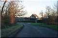
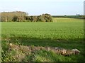
Owens Barn Farm
On a right angle bend this large farm with extensive modern and traditional buildings is the major feature of the featured square.
Image: © Kate Jewell
Taken: 3 Feb 2007
0.04 miles
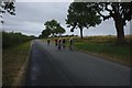
3
Looking towards Owens Barn Farm
There is extensive tree planting alongside this road that leads from Lenton to Folkingham. The buildings of Owns Barn Farm can just be seen in the middle distance.
Image: © Kate Jewell
Taken: 3 Feb 2007
0.08 miles
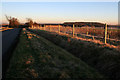
4
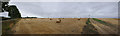
Big bales
This is just the left hand half of the Panorama at Image
It has the country lane on the left, and the field track on the right, which are around 90 degrees apart.
Image: © Bob Harvey
Taken: 12 Aug 2018
0.12 miles
5
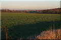
Lincolnshire farmland near Folkingham
Looking northeast from the Lenton to Folkinham road above Owens Barn Farm.
Image: © Kate Jewell
Taken: 3 Feb 2007
0.13 miles
7
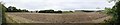
Field and trees
This panorama is nearly 180 degrees wide, with the hedges along the lane on either side.
Image: © Bob Harvey
Taken: 12 Aug 2018
0.15 miles
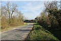
8
Fields and woodland near the Warren
To the west of Folkingham.
Image: © Oliver Dixon
Taken: 20 Apr 2017
0.16 miles
9
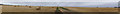
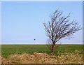
Harvested fields
A single, privately owned, wind turbine is on the highest spot in the area.
The Paonrama, centred on the field track on the map, is nearly 180 degrees wide.
Image: © Bob Harvey
Taken: 12 Aug 2018
0.17 miles