IMAGES TAKEN NEAR TO
West Road, SLEAFORD, NG34 0QU
Introduction
This page details the photographs taken nearby to West Road, NG34 0QU by members of the Geograph project.
The Geograph project started in 2005 with the aim of publishing, organising and preserving representative images for every square kilometre of Great Britain, Ireland and the Isle of Man.

There are currently over 7.5m images from over14,400 individuals and you can help contribute to the project by visiting https://www.geograph.org.uk
Image Map
Images are licensed for reuse under creativecommons.org/licenses/by-sa/2.0
Notes
- Clicking on the map will re-center to the selected point.
- The higher the marker number, the further away the image location is from the centre of the postcode.
Image Listing (84 Images Found)
Images are licensed for reuse under creativecommons.org/licenses/by-sa/2.0
Image
Details
Distance
1
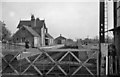
Billingborough & Horbling Station (remains)
View southwards, towards Bourne; ex-GN Bourne - Sleaford branch. Station and line closed to passengers 22/9/30, to goods 28/7/56 (from Sleaford) 15/6/64 (from Bourne).
Image: © Ben Brooksbank
Taken: 16 Apr 1961
0.02 miles
2
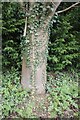
An outbreak of symmetry
Ivy growing on the trunk of a roadside tree.
Image: © Bob Harvey
Taken: 15 Apr 2018
0.02 miles
3
The old railway station at Billingborough, near Bourne, Lincolnshire
The railway station at Billingborough was built in 1872 to serve the villages of Billingborough, Horbling and Threekingham on the Bourne and Sleaford railway run by the Great Northern Railway Company. It closed to passengers in 1930 although the section from Bourne to Billingborough remained open for goods until 1964 and the station buildings became the headquarters of a local haulage company.
Image: © Rex Needle
Taken: 18 Mar 2000
0.04 miles
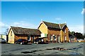
5
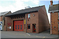
Billingborough fire station
Billingborough fire station, 8 High Street, Billingborough, Lincolnshire
Image: © Kevin Hale
Taken: 31 May 2008
0.07 miles
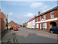
6
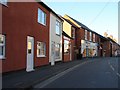
View of Billingborough High Street
Taking in the "Lucky Jade" and the Co-op.
Image: © Ian Paterson
Taken: 17 Feb 2008
0.07 miles
7

Billingborough & Horbling railway station (site), Lincolnshire
Opened in 1872 by the Bourne and Sleaford Railway which was part of the Great Northern Railway empire, this station closed to passengers in 1930 and completely in 1964.
View south towards Rippingale and Bourne. As with other former stations on the line, it is now a private residence.
Image: © Nigel Thompson
Taken: 11 Nov 2012
0.07 miles
8
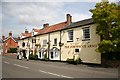
The Fortescue Arms
Popular inn on Billingborough High Street
Image: © Richard Croft
Taken: 9 Aug 2007
0.07 miles
9
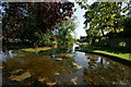
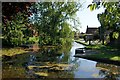
Spring Wells, Billingborough
This spot is known as Spring Wells. Only once in recent years have the springs been known to fail. On 1st January 1967, after several dry seasons, they dried up and remained dry for six weeks before re-appearing. Summer and winter alike, the temperature of the springs is a degree or two above freezing.
Image: © Dave Hitchborne
Taken: 26 Aug 2013
0.08 miles
10
Spring Wells, Billingborough
This spot is known as Spring Wells. Only once in recent years have the springs been known to fail. On 1st January 1967, after several dry seasons, they dried up and remained dry for six weeks before re-appearing. Summer and winter alike, the temperature of the springs is a degree or two above freezing.
Image: © Dave Hitchborne
Taken: 26 Aug 2013
0.08 miles