IMAGES TAKEN NEAR TO
High Street, SLEAFORD, NG34 0QB
Introduction
This page details the photographs taken nearby to High Street, NG34 0QB by members of the Geograph project.
The Geograph project started in 2005 with the aim of publishing, organising and preserving representative images for every square kilometre of Great Britain, Ireland and the Isle of Man.

There are currently over 7.5m images from over14,400 individuals and you can help contribute to the project by visiting https://www.geograph.org.uk
Image Map (80 Images)


Getting Data...Please wait
Leaflet Map data © OpenStreetMap
Images are licensed for reuse under creativecommons.org/licenses/by-sa/2.0
Notes
- Clicking on the map will re-center to the selected point.
- The higher the marker number, the further away the image location is from the centre of the postcode.
Image Listing (80 Images Found)
Images are licensed for reuse under creativecommons.org/licenses/by-sa/2.0
Image
Details
Distance
1
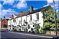
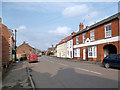
The Fortescue Arms at Billingborough, near Bourne, Lincolnshire
The Fortescue Arms is an imposing whitewashed public house in the village High Street named after a wealthy land owning family and Lords of the Manor and now embracing several properties although the original inn was built 300 years ago with stone reputed to have come from Sempringham Priory after it was sacked by Cromwell's troops during the Civil War.
Image: © Rex Needle
Taken: 12 Sep 2000
0.00 miles
3
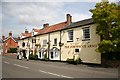
The Fortescue Arms
Popular inn on Billingborough High Street
Image: © Richard Croft
Taken: 9 Aug 2007
0.05 miles
4
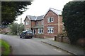
Buckminster House
This was a children's home in 1955 when my sister and I were placed there after my mother contracted tuberculosis. The foreground was at that time a lawn. We children had to pick out all the stones before the lawn was seeded, and I found a George III cartwheel penny dating from 1797.
Image: © Peter Langsdale
Taken: 2 Jan 2003
0.06 miles
6
Buckminster Old House, Billingborough
This was just called "Buckminster House" in 1955 when I lived there, in the then children's home. Where the red bushes are on the right was our playground, a sandy area where I practised the high jump, among other things. At a guess, there were about 30 children, and a staff of perhaps 10.
Image: © Peter Langsdale
Taken: Unknown
0.06 miles
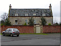
7
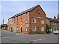
Converted grain store, Billingborough, Lincs
on the corner of Birthorpe Road and High Street, formerly the business place of Harrison Corn Merchant.
Image: © Rodney Burton
Taken: 5 Aug 2006
0.07 miles
8
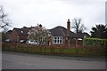
Bungalow with Magnolia
It is clear to see where the name "Candle Tree" comes from
Image: © Bob Harvey
Taken: 15 Apr 2018
0.07 miles
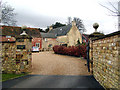
10
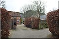
Shared Entrance
What was once the Manor gateway is now shared by the several homes developed in the farm buildings
Image: © Bob Harvey
Taken: 15 Apr 2018
0.08 miles