IMAGES TAKEN NEAR TO
Kirkby Underwood Road, SLEAFORD, NG34 0HP
Introduction
This page details the photographs taken nearby to Kirkby Underwood Road, NG34 0HP by members of the Geograph project.
The Geograph project started in 2005 with the aim of publishing, organising and preserving representative images for every square kilometre of Great Britain, Ireland and the Isle of Man.

There are currently over 7.5m images from over14,400 individuals and you can help contribute to the project by visiting https://www.geograph.org.uk
Image Map
Images are licensed for reuse under creativecommons.org/licenses/by-sa/2.0
Notes
- Clicking on the map will re-center to the selected point.
- The higher the marker number, the further away the image location is from the centre of the postcode.
Image Listing (9 Images Found)
Images are licensed for reuse under creativecommons.org/licenses/by-sa/2.0
Image
Details
Distance
1
High Park Cottage, Aslackby Road
Close to High Park Farm. The cottage enjoys good views south towards Kirkby Underwood
Image: © Tim Heaton
Taken: 24 Jan 2023
0.02 miles
2

High Park Cottage
High Park Cottage from Kirkby Underwood Road
Image: © Richard Croft
Taken: 12 Jul 2012
0.02 miles
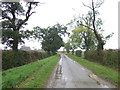
4
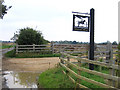
Farm entrance, Aslackby, Lincs
with sign for Victoria Farm.
Image: © Rodney Burton
Taken: 26 Aug 2006
0.14 miles
5
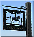
Sign for Victoria Farm
A close up of the fine metal work sign.
Image: © Kate Jewell
Taken: 18 Apr 2007
0.16 miles
6

Victoria Farm bridleway
Bridleway to Mareham Lane via Victoria Farm
Image: © Richard Croft
Taken: 12 Jul 2012
0.17 miles
7
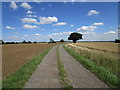
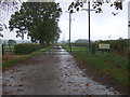
Roadway to Victoria Farm
The roadway is also a bridleway to the A15.
Image: © Jonathan Thacker
Taken: 24 Aug 2020
0.20 miles
9
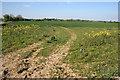
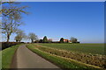
Farmland near Aslackby
Halfway between Kirkby Underwood and Aslackby; the farmland is quite exposed here at 55 metres above sea level.
Image: © Kate Jewell
Taken: 18 Apr 2007
0.25 miles