
IMAGES TAKEN NEAR TO
Haceby, SLEAFORD, NG34 0EG
Introduction
This page details the photographs taken nearby to NG34 0EG by members of the Geograph project.
The Geograph project started in 2005 with the aim of publishing, organising and preserving representative images for every square kilometre of Great Britain, Ireland and the Isle of Man.

There are currently over 7.5m images from over14,400 individuals and you can help contribute to the project by visiting https://www.geograph.org.uk
Image Map
Images are licensed for reuse under creativecommons.org/licenses/by-sa/2.0
Notes
- Clicking on the map will re-center to the selected point.
- The higher the marker number, the further away the image location is from the centre of the postcode.
Image Listing (81 Images Found)
Images are licensed for reuse under creativecommons.org/licenses/by-sa/2.0
Image
Details
Distance
2
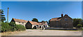
Moat farm and outbuildings
The two story farmhouse is from around 1860, and the whole collection is one of the 19th century "model farms" that revolutionised the industry
The single storey buildings to the left are a grade ii listed building (https://historicengland.org.uk/listing/the-list/list-entry/1360585 ) as are the range of farm buildings to the extreme left (https://historicengland.org.uk/listing/the-list/list-entry/1147802 )
The name Moat Farm comes from the scheduled ancient monument to the east of the buildings (https://historicengland.org.uk/listing/the-list/list-entry/1004964 ) which is thought to be medieval or even later (http://www.pastscape.org.uk/hob.aspx?hob_id=348667&sort=2&rational=m&recordsperpage=10&mapisa=1000&mapist=os&mapigrn=335500&mapigre=502500#aSt )
Image: © Bob Harvey
Taken: 30 Jun 2018
0.02 miles
4
Haceby
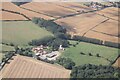
Buildings associated with Moat Farm at Haceby
Image: © Richard Croft
Taken: 21 May 2009
0.03 miles
5

Boarded up cottages, Haceby
OS seems to show this as two cottages, in which case of the five dwellings in the hamlet of Haceby three are boarded up. Does this make Haceby the most derelict community in England?
Image: © Jonathan Thacker
Taken: 9 Aug 2025
0.03 miles

7
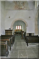
Interior of Haceby Church
St Margaret's Church, sometimes known as St Barbara's, in Haceby has a fine painted decoration on the chancel arch. It shows the arms of Queen Anne which was restored in 1979. It was painted over a Medieval "Doom" and you can still make out angels herding a crowd of sinners onto the path to Hell on the right hand side. See http://homepages.which.net/~rex/bourne/haceby.htm for further information about the village and church although the site is open and the church easy to access now. It is managed by the Churches Conservation Trust and there is an informative leaflet available by the font. http://www.visitchurches.org.uk/frontpage.asp for info about the CCT.
Image: © Kate Jewell
Taken: 18 Apr 2006
0.03 miles
8
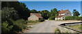
Haceby
Only two dwellings and a redundant church stand where Medieval Haceby once stood.
Image: © Bob Harvey
Taken: 30 Jun 2018
0.03 miles
10
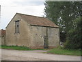
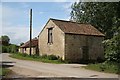
Granary at Haceby
Typical of the smaller agricultural buildings of these parts.
Image: © Jonathan Thacker
Taken: 31 Aug 2012
0.04 miles