IMAGES TAKEN NEAR TO
High Street, SLEAFORD, NG34 0DW
Introduction
This page details the photographs taken nearby to High Street, NG34 0DW by members of the Geograph project.
The Geograph project started in 2005 with the aim of publishing, organising and preserving representative images for every square kilometre of Great Britain, Ireland and the Isle of Man.

There are currently over 7.5m images from over14,400 individuals and you can help contribute to the project by visiting https://www.geograph.org.uk
Image Map
Images are licensed for reuse under creativecommons.org/licenses/by-sa/2.0
Notes
- Clicking on the map will re-center to the selected point.
- The higher the marker number, the further away the image location is from the centre of the postcode.
Image Listing (121 Images Found)
Images are licensed for reuse under creativecommons.org/licenses/by-sa/2.0
Image
Details
Distance
1
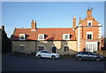
Grange Cottage
Dating from 1784 this is a grade II listed building. The roof pitch, dormers, and chimney suggest it was once thatched. See Image for the datestone above the door.
See https://historicengland.org.uk/listing/the-list/list-entry/1061761
The tall building on the right, Image, with prominent quoins, was built a little later, in Georgian brick not vernacular stone. It, too, is a listed building, see https://historicengland.org.uk/listing/the-list/list-entry/1360609.
Image: © Bob Harvey
Taken: 20 Jan 2019
0.01 miles
2
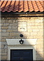
Datestone
Above the door of Image is this datestone, inscribed 'Robert Bradley 1784'.
Image: © Bob Harvey
Taken: 20 Jan 2019
0.01 miles
3
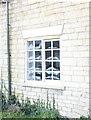
High quality stonework
Although Image appears to have been built in a vernacular style, it was a high quality building - the regularity of the stones, the flush faces, the quality of the coursework is undeniable. The lovely lintel is sitting as true as the day it was laid.
I was also interested, on this very chilly day, to see the tell-tale marks of chill on the windows, something that modern double glazed houses do not suffer from any more. The perils of a grade II listed building, eh?
Image: © Bob Harvey
Taken: 20 Jan 2019
0.01 miles
4
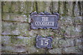
The Coggarth
The house at the end of Image has a most unusual name. "The Coggarth"
Now, I am guessing here, but we are in the Danelaw, where a Garth is an enclosed bit of land, from the Old Norse garðr "yard". Cog is another thing altogether. Ignoring all the associations with gearwheels, this might mean a hill or high ground, or it might mean an act of cheating at cards. Or it might mean a protruding tenon in a wooden frame.
But far more interestingly, a "Cog" is a dialect word for a Cuckoo, (pronounced with a vowel half way between 'o' and 'u' and probably onomatopoeic). One source links it with "gowk", also a Cuckoo.
There are several places in Lincolnshire known as Cuckoobush, which have legends of simple-minded folk building a fence around a bush to restrain the Cuckoo, often because they are enchanted by the bird's "beautiful song". Perhaps the Garth here was for a Cuckoo too?
I have no idea at all why this is called Coggarth - which has been a surname in the past. But I really like the Cuckoo idea.
Image: © Bob Harvey
Taken: 20 Jan 2019
0.01 miles
5
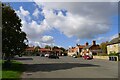
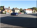
Centre of Osbournby
A huge area of tarmac. One feels there should be a green.
Image: © Tim Heaton
Taken: 10 Oct 2022
0.01 miles
6
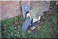
No eggs
Beside the service valve sign (I looked for the associated valve cover and could not find it. I suspect it has been tarmac'd over) is this little model house, normally used for displaying fresh eggs for sale. The lady owner told me that the hens are off lay, and she blamed the dry weather.
Image: © Bob Harvey
Taken: 20 Jan 2019
0.01 miles
7
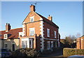
30 High Street
A grade II listed building in Georgian style, facing the side lane not the village square. The single storey extension with the bay window was added in the 20th century, and served as a Butcher's shop in living memory.
See https://historicengland.org.uk/listing/the-list/list-entry/1360609
Image: © Bob Harvey
Taken: 20 Jan 2019
0.01 miles
9
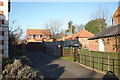
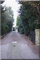
Truncated lane
This former byway, now the shared access for a handful of homes, is the lane referred to in Image as the one that the large house on the left is built to face
Image: © Bob Harvey
Taken: 20 Jan 2019
0.02 miles