IMAGES TAKEN NEAR TO
Saltersway, SLEAFORD, NG34 0AU
Introduction
This page details the photographs taken nearby to Saltersway, NG34 0AU by members of the Geograph project.
The Geograph project started in 2005 with the aim of publishing, organising and preserving representative images for every square kilometre of Great Britain, Ireland and the Isle of Man.

There are currently over 7.5m images from over14,400 individuals and you can help contribute to the project by visiting https://www.geograph.org.uk
Image Map
Images are licensed for reuse under creativecommons.org/licenses/by-sa/2.0
Notes
- Clicking on the map will re-center to the selected point.
- The higher the marker number, the further away the image location is from the centre of the postcode.
Image Listing (107 Images Found)
Images are licensed for reuse under creativecommons.org/licenses/by-sa/2.0
Image
Details
Distance
1
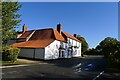
Salters Way
The road through Threekingham is now called "Salter's Way", a name which is linked to the road between Droitwich and Boston. See also Slatersford on the Witham south of Grantham (see Image). The accounts given in local histories are however fairly disparate: the church history suggests that Salt from saltpans in the wash was traded toward the midlands, and the village web site that Salt from Drowitich was traded toward the east coast ports.
Image: © Bob Harvey
Taken: 24 Sep 2014
0.04 miles
3
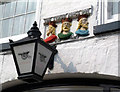
Kings over the door
These are above the entrance to the Three Kings Inn.
Image: © Des Blenkinsopp
Taken: 27 Mar 2014
0.06 miles
4
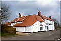
The Three Kings
In a village called Threekingham what else would the pub be called?
My Dictionary of Place Names is a bit vague about how this name came about.
Trichingeham in the Domesday book, the suggestion is that the first element comes from old English "Threkkr" meaning mud, combined with the frequently found "ingham" suffix.
So, a muddy place. Not that exciting, really.
Image: © Des Blenkinsopp
Taken: 27 Mar 2014
0.06 miles
5
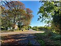
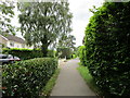
Saltersway entering Threekingham
The original route of the A52 through the village before the bypass was built, and presumably on the line of the Salt Way Roman road.
(Note that the street sign says 'Salters Way', but 'Saltersway' appears to be the preferred spelling)
Image: © Tim Heaton
Taken: 10 Oct 2022
0.06 miles
6
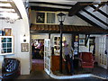
Leaning on a lamppost
The former archway through to the rear of the Three Kings Inn was converted to an indoor space some time in the 1970s. It has been made to look a little like a Dickensian street, albeit one with armchairs. The Lamppost is part of that. It is genuine Victorian cast iron lamp.
Image: © Bob Harvey
Taken: 24 Sep 2014
0.06 miles
7
Three Kings Inn, Saltersway, Threekingham
Listed Grade II, early 18th century https://historicengland.org.uk/listing/the-list/list-entry/1061736?section=official-list-entry .
The following from the Threekingham parish website:
"The Three Kings Inn: Reputedly, a hostelry has been on the site of The Three Kings Inn for centuries. An ailing King John stayed at the Inn during October 1216 when he was en route from Swineshead Abbey to Newark Castle where he died. Three centuries later, on the 8th August 1554, King Henry VIII passed through the village on his way to York and returned a few weeks later. In the 18th Century the Inn was known as the Harvest Home and then the Barley Mow. In about 1737, Dick Turpin's mother-in-law, Mrs Berrys, ran the Inn, and he frequently visited her to feed his horse before he set out to rob travellers on Salters Way." http://www.threekingham.org.uk/about_3kh.html
Image: © Tim Heaton
Taken: 10 Oct 2022
0.06 miles
8
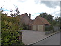
Mock Dovecote
A small estate of very expensive houses have been built on the former farm next to Threekingham Church. each of them features one of these mock dovecotes somewhere in the brickwork.
Image: © Bob Harvey
Taken: 24 Sep 2014
0.08 miles