IMAGES TAKEN NEAR TO
North Beck, SLEAFORD, NG34 0AD
Introduction
This page details the photographs taken nearby to North Beck, NG34 0AD by members of the Geograph project.
The Geograph project started in 2005 with the aim of publishing, organising and preserving representative images for every square kilometre of Great Britain, Ireland and the Isle of Man.

There are currently over 7.5m images from over14,400 individuals and you can help contribute to the project by visiting https://www.geograph.org.uk
Image Map
Images are licensed for reuse under creativecommons.org/licenses/by-sa/2.0
Notes
- Clicking on the map will re-center to the selected point.
- The higher the marker number, the further away the image location is from the centre of the postcode.
Image Listing (48 Images Found)
Images are licensed for reuse under creativecommons.org/licenses/by-sa/2.0
Image
Details
Distance
3
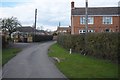
Entering the Village
Entering the village of Northbeck from the footbridge, as though coming from Screddington
Image: © Bob Harvey
Taken: 25 Mar 2018
0.03 miles
5
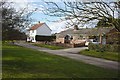
Ramshackle arrangements
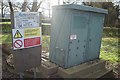
The control cubicle and some warning signs at Image
Image: © Bob Harvey
Taken: 25 Mar 2018
0.03 miles
6
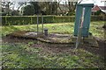
Water Infrastructure
This looks like a pump head to me. I suspect they are extracting water from the North Beck. There is a brick structure in the bank visible in Image which looks to me like the point of extraction
Image: © Bob Harvey
Taken: 25 Mar 2018
0.03 miles
7
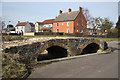
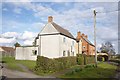
Packhorse Bridge
Packhorse bridge at Northbeck, known locally as Roman Bridge, probably due to its proximity to Mareham Lane. Sometimes said to date from 1250, but most likely built in the 17th century and not technically a packhorse bridge as it's about 3m wide. The ford through North Beck has been replaced by a road and the bridge restored by Lincolnshire County Council in 2004.
Image: © Richard Croft
Taken: 5 Mar 2010
0.04 miles
9
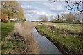
Looking East from the footbridge
This is the stream called the North Beck. It is one of two natural waterways draining the low-lying land south of Sleaford (the other being the South Beck, which joins it a little to the west of here).
There is a ridge of high ground, the Burton Cliff, and this stream has cut through it south of Burton Penwardine, to reach the ancient seashore somewhere around Bicker. It now flows into the South Forty Foot, diverting it to Boston.
Image: © Bob Harvey
Taken: 25 Mar 2018
0.05 miles
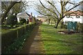
10

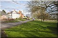
The other bridge
There are two bridges in Northbeck, the ancient packhorse bridge and this modern footbridge, on the path over the fields to Scredington.
Image: © Bob Harvey
Taken: 25 Mar 2018
0.05 miles