IMAGES TAKEN NEAR TO
Livingstone Road, NOTTINGHAM, NG3 3GG
Introduction
This page details the photographs taken nearby to Livingstone Road, NG3 3GG by members of the Geograph project.
The Geograph project started in 2005 with the aim of publishing, organising and preserving representative images for every square kilometre of Great Britain, Ireland and the Isle of Man.

There are currently over 7.5m images from over14,400 individuals and you can help contribute to the project by visiting https://www.geograph.org.uk
Image Map
Images are licensed for reuse under creativecommons.org/licenses/by-sa/2.0
Notes
- Clicking on the map will re-center to the selected point.
- The higher the marker number, the further away the image location is from the centre of the postcode.
Image Listing (52 Images Found)
Images are licensed for reuse under creativecommons.org/licenses/by-sa/2.0
Image
Details
Distance
1
The Chase
1970s pub at the foot of Robin Hood Chase.
Image: © Alan Murray-Rust
Taken: 8 Mar 2009
0.02 miles
2
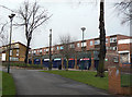
Shops at Robin Hood Chase
This is the main commercial centre of the St Anns area.
Image: © Alan Murray-Rust
Taken: 8 Mar 2009
0.03 miles
3
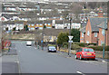
Looking down Southampton Street
Until the 1960s, St Anns was a warren of densely packed terraced housing from the first half of the 19th century. This was all swept away in a major redevelopment from the late 1960s onwards.
Image: © Alan Murray-Rust
Taken: 8 Mar 2009
0.03 miles
4
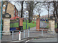
Entrance to Robin Hood Chase
The Victorian gateposts have been supplemented by a modern archway.
Robin Hood Chase is part of the green corridor stretching round the north and east of the City Centre from the Arboretum to St Anns Well Road, built around the 1870s.
Image: © Alan Murray-Rust
Taken: 8 Mar 2009
0.04 miles
5
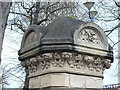
Gatepost on Robin Hood Chase
One of the gateposts at the St Anns Well Road entrance to Robin Hood Chase. The semicircular panel at the top is clearly a rose, but I can't identify the plants on the frieze.
See Elm Avenue and the Chase capitals http://www.geograph.org.uk/search.php?i=5558919&displayclass=slide
Image: © Alan Murray-Rust
Taken: 8 Mar 2009
0.04 miles
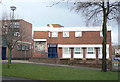
6
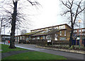
The Chase Centre
Community Centre for St Anns.
A modern building - note the deliberately vegetated roof.
Image: © Alan Murray-Rust
Taken: 8 Mar 2009
0.04 miles
7
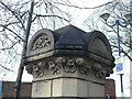
Gatepost on Robin Hood Chase
One of the gateposts at the St Anns Well Road entrance to Robin Hood Chase. I can't identify the plants on this one.
See Elm Avenue and the Chase capitals http://www.geograph.org.uk/search.php?i=5558919&displayclass=slide
Image: © Alan Murray-Rust
Taken: 8 Mar 2009
0.05 miles
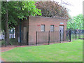
8
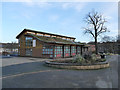
The Chase Neighbourhood Centre
The 'green' (sedum) roof suggests a date later than the 1970s of the surrounding buildings.
Image: © Stephen Craven
Taken: 18 Jan 2020
0.05 miles
9
Disused Public Toilets, Robin Hood Chase
There are a number of former public toilets scattered around the city: many simple brick structures like this one. Many are not in places with a high footfall: I suspect that their locations were partly determined by the needs of Nottingham City Transport drivers.
Others are (or were located) at: junction of ring-road and Wilkinson Street, Abbey Bridge/Castle Boulevard roundabout, Charnock Walk (men) and Lenton Lodge (women), Carrington Street (now munch:munch fast food outlet).
Image: © SK53
Taken: 26 Apr 2011
0.06 miles
10
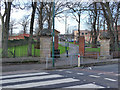
Eastern entrance to Robin Hood Chase
The Chase is one of the areas comprising the 130 acres of land to the north and east of Nottingham city centre set aside by the 1845 Enclosure Act as public open space. The stone pillars look to be original, but the area either side of the linear open space was completely redeveloped from the 1970s.
Image: © Stephen Craven
Taken: 18 Jan 2020
0.07 miles