IMAGES TAKEN NEAR TO
Sketchley Street, NOTTINGHAM, NG3 3DX
Introduction
This page details the photographs taken nearby to Sketchley Street, NG3 3DX by members of the Geograph project.
The Geograph project started in 2005 with the aim of publishing, organising and preserving representative images for every square kilometre of Great Britain, Ireland and the Isle of Man.

There are currently over 7.5m images from over14,400 individuals and you can help contribute to the project by visiting https://www.geograph.org.uk
Image Map
Images are licensed for reuse under creativecommons.org/licenses/by-sa/2.0
Notes
- Clicking on the map will re-center to the selected point.
- The higher the marker number, the further away the image location is from the centre of the postcode.
Image Listing (16 Images Found)
Images are licensed for reuse under creativecommons.org/licenses/by-sa/2.0
Image
Details
Distance
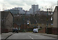
1
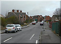
Blue Bell Hill Road
This point is where the 1970s redevelopment of St Anns stopped, and existing buildings stayed in place. However, even the terraced houses at the top of the hill would have been superior to the bulk of those replaced, and worth retaining.
Image: © Alan Murray-Rust
Taken: 8 Mar 2009
0.10 miles
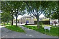
2
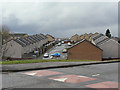
Melville Gardens
Part of the St Anns redevelopment of the early 1970s
Image: © Alan Murray-Rust
Taken: 8 Mar 2009
0.18 miles
3
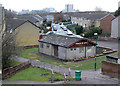
Church of Christ, Limmen Gardens
I don't think that this building was originally a church, and it certainly looks disused again now.
Image: © Alan Murray-Rust
Taken: 8 Mar 2009
0.19 miles
4
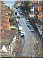
Donkey Hill
Officially St bartholomew's Road, it's always known locally by its nickname, although where this originates I do not know. The gradient is probably about 1 in 7.
Image: © Alan Murray-Rust
Taken: 8 Mar 2009
0.21 miles
5
Jersey Gardens
Part of the St Anns redevelopment of the early 1970s, with the Victoria Centre flats on the skyline.
Image: © Alan Murray-Rust
Taken: 8 Mar 2009
0.21 miles
6
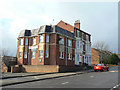
The Lord Alcester
Victorian pub on St Mathias Road, with modern extension.
Image: © Alan Murray-Rust
Taken: 8 Mar 2009
0.21 miles
7
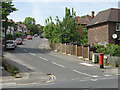
Alma Road
A quiet suburban street off Carlton Road.
Image: © Alan Murray-Rust
Taken: 29 May 2008
0.22 miles
8
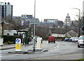
Beacon Hill Rise
Looking towards the City Centre.
This road was realigned as part of the St Anns redevelopment in the 1970s.
Image: © Alan Murray-Rust
Taken: 8 Mar 2009
0.22 miles
9
Heron Foods shop
Formerly "The Westminster" public house.
Image: © David Lally
Taken: 5 Jul 2016
0.23 miles
10
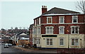
Nottingham, NG3 - St Ann's Area.
The former Lord Alcester pub, near the summit of St Mathias' Road, that was built in the 1950s and that has been converted into nine self-contained flats (2012). The premises, that are still called by their original name, have been extended on their Carlton Road side. The pub took its name from Admiral Frederick Beauchamp Paget Seymour, the 1st Lord Alcester (1821-95), the British naval Commander-in-Chief of the Channel Fleet between 1874-77 and of the Mediterranean Fleet between 1880-83.
Image: © David Hallam-Jones
Taken: 24 Jan 2013
0.23 miles