IMAGES TAKEN NEAR TO
The Wells Road, NOTTINGHAM, NG3 3AB
Introduction
This page details the photographs taken nearby to The Wells Road, NG3 3AB by members of the Geograph project.
The Geograph project started in 2005 with the aim of publishing, organising and preserving representative images for every square kilometre of Great Britain, Ireland and the Isle of Man.

There are currently over 7.5m images from over14,400 individuals and you can help contribute to the project by visiting https://www.geograph.org.uk
Image Map
Images are licensed for reuse under creativecommons.org/licenses/by-sa/2.0
Notes
- Clicking on the map will re-center to the selected point.
- The higher the marker number, the further away the image location is from the centre of the postcode.
Image Listing (38 Images Found)
Images are licensed for reuse under creativecommons.org/licenses/by-sa/2.0
Image
Details
Distance
1
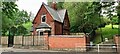
Lodge and entrance to City Heights Greenspace woodland on NE side of The Wells Road
Ordnance Survey documents indicate that a benchmark was levelled at 96.488m above Newlyn Datum in 1962 on the wall in the centre of the image. The wall appears to have been rebuilt.
Image: © Roger Templeman
Taken: 10 May 2022
0.03 miles
2
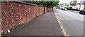
Looking SE along The Wells Road
There is an Ordnance Survey benchmark Image on the wall in the left foreground above a notebook positioned against the wall
Image: © Roger Templeman
Taken: 10 May 2022
0.03 miles
3
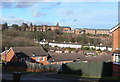
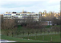
View across the Wells Road
The white houses are the original development on The Wells Road, with the nearer development being relatively recent. The skyline is dominated by Mapperley Hospital.
Image: © Alan Murray-Rust
Taken: 8 Mar 2009
0.05 miles
4

Benchmark on brick wall on NE side of The Wells Road
Ordnance Survey cut mark benchmark levelled at 104.217m above Newlyn Datum in 1962
Image: © Roger Templeman
Taken: 10 May 2022
0.08 miles
5
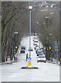
The Wells Road
This ends in a steep rise at its junction with Woodborough Road, which runs along the top of a ridge.
Image: © Alan Murray-Rust
Taken: 8 Mar 2009
0.09 miles
6
Elliot Durham School
1960s built comprehensive for east Nottingham
Image: © Alan Murray-Rust
Taken: 8 Mar 2009
0.11 miles
7
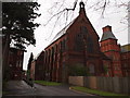
Nottingham - NG5
This former chapel and recreation hall block, together with the wooden fence, form the boundary between what was once Mapperley mental hospital – much of which has been redeveloped into the “City Heights” housing complex – and the remaining part of the site that continues to function as a much smaller mental health unit. This view from the north west shows an internal hospital road that is used for vehicles accessing the rear of "Duncan Macmillan House". This imposing two-storey building is constructed of brick with a pitched slate roof, the former chapel occupying the upper part of it and the former recreation hall the ground floor unit, both constructed as separate entities. This twin-purpose block was completed in 1888 as part of a further extension of the hospital’s capacity. Further information can be found at www2.warwick.ac.uk/fac/arts/arthistory/research/staffinterests/ja/alexander.pdf
Image: © David Hallam-Jones
Taken: 21 Apr 2012
0.13 miles
8
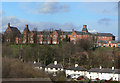
Mapperley Hospital, Male Wing
Opened in 1880 as the Nottingham Borough Asylum, and closed as a hospital in 1994. Parts are still in use as a Psychiatric Unit, but this wing has been converted into apartments.
Image: © Alan Murray-Rust
Taken: 8 Mar 2009
0.14 miles
9
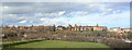
Panorama of Mapperley Hospital
This was opened in 1880 as the Nottingham Borough Asylum, and "You'll end up in Mapperley" was common local usage when anyone acted strangely. It closed as a mental hospital in 1994, although a large part is still used by the NHS.
The buildings are strung out along a ridge and can be seen to advantage from this location. The main left hand wing was the female wing, with the superintendents dwelling next to it. This part is now Duncan Macmillan House, which includes a psychiatric unit and training facilities. Further right is the chapel, and the main right hand wing was the male wing. This has now been converted into apartments, together with the new buildings at the right hand side of the picture.
The buildings were designed by G.T.Hine, son of the architect of the nearby Coppice Hospital. Hine's work at Mapperley launcehed him as consultant architect to H.M. Commissioners for Lunacy. (source: Pevsner, Nottinghamshire)
Image: © Alan Murray-Rust
Taken: 8 Mar 2009
0.14 miles
10
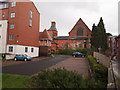
Nottingham - NG3
On the right-hand side of this fence is one of the internal roads of the now defunct Mapperley psychiatric hospital seen passing the side of part of Duncan Macmillan House, the only section of the hospital still providing mental health services. Behind the black car on the left-hand side of the fence one of the end elevations of the derelict hospital church can be seen. The older building to the left of the church is "Nightingale House" on Ockbrook Drive, a part of this Victorian hospital that has been converted into modern apartments. Complementing this older section of the former hospital one of several new apartment blocks are also apparent.
Image: © David Hallam-Jones
Taken: 21 Apr 2012
0.17 miles