IMAGES TAKEN NEAR TO
Mill Lane, GRANTHAM, NG33 5QN
Introduction
This page details the photographs taken nearby to Mill Lane, NG33 5QN by members of the Geograph project.
The Geograph project started in 2005 with the aim of publishing, organising and preserving representative images for every square kilometre of Great Britain, Ireland and the Isle of Man.

There are currently over 7.5m images from over14,400 individuals and you can help contribute to the project by visiting https://www.geograph.org.uk
Image Map
Images are licensed for reuse under creativecommons.org/licenses/by-sa/2.0
Notes
- Clicking on the map will re-center to the selected point.
- The higher the marker number, the further away the image location is from the centre of the postcode.
Image Listing (18 Images Found)
Images are licensed for reuse under creativecommons.org/licenses/by-sa/2.0
Image
Details
Distance
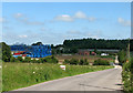
1

Shades of blue
This huge cluster of Genie Terex Articulating Boom Lifts, like a flock of giant bright blue metallic birds, or Anglepoise lamps, is a surprising and rather photogenic sight in the middle of green South Lincolnshire countryside just west of South Witham, at the Mill Lane Industrial estate.
Image: © John Sutton
Taken: 17 Jun 2010
0.06 miles
2
Mill Lane Industrial Estate, near South Witham
A huge cluster of Genie Terex Articulating Boom Lifts is a surprising and rather photogenic sight in the middle of green South Lincolnshire countryside, at Mill Lane Industrial Estate.
The industrial estate at South Witham was originally the site of the engine sheds, loading sidings, crusher and offices of Thistleton Mines. Considerable reserves of ironstone – usually extracted by opencast quarrying in the East Midlands – lay below a 60ft bed of Lincolnshire limestone, and it was decided to mine it. The mining complex was built from 1955-7. A 22ft-diameter steel-arch/concrete-segment tunnel was driven 500 yards southwards on a 1 in 40 gradient. The mines were served by a modern double-track narrow-gauge railway operated by one electric and two diesel locomotives, which hauled trains of twelve-ton wagons known as minecars. The mines stretched a mile and a half south and half a mile west, under and beyond the present South Witham limestone quarry. Many of the miners were Scottish coal miners, who lived in houses built for them in South Witham. Production peaked at 390,000 tons a year (and not the million envisaged), but geological difficulties and seepage led to closure on 27 June 1964. The belief that in the second half of the twentieth century it would be necessary to mine ironstone proved misguided: economics prevailed – with the introduction of big dragline excavators, opencast was cheaper. The comparable Easton Mines, near Colsterworth, were equally short-lived, closing in 1967.
Image: © John Sutton
Taken: 17 Jun 2010
0.07 miles
3
Boom Lifts at Mill Lane Industrial Estate
This huge cluster of Genie Terex Articulating Boom Lifts, like a flock of giant bright blue metallic birds, or Anglepoise lamps, is a surprising and rather photogenic sight in the middle of green South Lincolnshire countryside just west of South Witham, at the Mill Lane Industrial estate.
Image: © John Sutton
Taken: 17 Jun 2010
0.07 miles
4
Private road
The plant hire and storage depot, and a few other businesses, occupy what was the headquarters of the former ironstone mining in this area.
Image: © Bob Harvey
Taken: 29 Jun 2024
0.08 miles
5

Bridge over the Witham
The road here, immediately this side of the gate, crosses the River Witham. The gate gives access to a large plant storage depot, and the river is all but invisible. It can be glimpsed through the railings next to the post box on the right.
Image: © Bob Harvey
Taken: 29 Jun 2024
0.10 miles
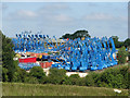
6
Blue boom lifts at Mill Lane Industrial Estate
This cluster of Genie Terex Articulating Boom Lifts, like a flock of giant bright blue metallic birds, or Anglepoise lamps, is a surprising and rather photogenic sight in the middle of green South Lincolnshire countryside just west of South Witham, at the Mill Lane Industrial estate.
Image: © John Sutton
Taken: 17 Jun 2010
0.10 miles
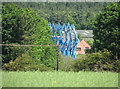
7
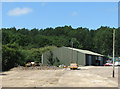
Mill Lane Industrial Estate - once Thistleton Mines
This picture shows one of the industrial units and the trees which cover what was until 1964 the entrance tunnel to the Thistleton ironstone mine.
The industrial estate was originally the site of the engine sheds, loading sidings, crusher and offices of Thistleton Mines. Considerable reserves of ironstone – usually extracted by opencast quarrying in the East Midlands – lay below a 60ft bed of Lincolnshire limestone, and it was decided to mine it. The mining complex was built from 1955-7. A 22ft-diameter steel-arch/concrete-segment adit was driven 500 yards southwards on a 1 in 40 gradient. The mines were served by a modern double-track narrow-gauge railway operated by one electric and two diesel locomotives, which hauled trains of twelve-ton wagons known as minecars. The mines stretched a mile and a half south and half a mile west, under the present South Witham limestone quarry and south of the old Saxby to Bourne railway. Many of the miners were Scottish coal miners, who lived in houses built for them in South Witham. Production peaked at 390,000 tons a year (and not the million envisaged), but geological difficulties and seepage led to closure on 27 June 1964. The belief that in the second half of the twentieth century it would be necessary to mine ironstone proved misguided: economics prevailed – with the introduction of big dragline excavators, opencast was cheaper. The comparable Easton Mines, near Colsterworth, were equally short-lived, closing in 1967.)
Image: © John Sutton
Taken: 17 Jun 2010
0.11 miles

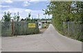
9

Access road
The road to the small industrial estate on the site of the former ironstone works.
Image: © Bob Harvey
Taken: 29 Jun 2024
0.13 miles
10

Mill Lane Industrial Estate, South Witham
Image: © Tim Heaton
Taken: 11 Dec 2005
0.14 miles