IMAGES TAKEN NEAR TO
Newton Way, GRANTHAM, NG33 5NP
Introduction
This page details the photographs taken nearby to Newton Way, NG33 5NP by members of the Geograph project.
The Geograph project started in 2005 with the aim of publishing, organising and preserving representative images for every square kilometre of Great Britain, Ireland and the Isle of Man.

There are currently over 7.5m images from over14,400 individuals and you can help contribute to the project by visiting https://www.geograph.org.uk
Image Map
Images are licensed for reuse under creativecommons.org/licenses/by-sa/2.0
Notes
- Clicking on the map will re-center to the selected point.
- The higher the marker number, the further away the image location is from the centre of the postcode.
Image Listing (107 Images Found)
Images are licensed for reuse under creativecommons.org/licenses/by-sa/2.0
Image
Details
Distance
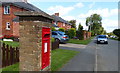
1
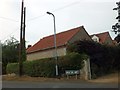
Road sign for Newton Way, Woolsthorpe-by-Colsterworth
Image: © David Smith
Taken: 22 Jul 2013
0.04 miles
2
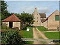
Woolsthorpe Manor, Isaac Newton's home
A view of Woolsthorpe Manor and associated farm buildings. The Building on the left is now the National Trust reception area and shop.
Image: © Paul Shreeve
Taken: 14 Sep 2008
0.06 miles
3
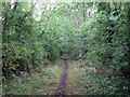
Woolsthorpe: trackbed of the High Dyke Branch
The High Dyke branch was built during the First World War to carry iron ore from quarries at Colsterworth, Skillington, Buckminster, Gunby and Sproxton to the East Coast Main line (the junction and sidings were in square SK9329) and closed in 1973. This view is looking towards Colsterworth North Sidings and High Dyke. See other photos nearby for more on the railways and quarries in the area.
Image: © John Sutton
Taken: 27 Aug 2009
0.10 miles
4
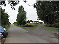
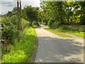
Woolsthorpe: new and old Buckminster roads
The course of the road was moved to the south of the High Dyke Branch railway in 1966 as ironstone quarrying in the huge Colsterworth North Quarry, which took up all of the northern half of this gridsquare (and SK9124), moved south. The truncated old road is to the right, the current road to the left. The High Dyke Branch crossed the old road on the crest of the hill, just beyond the bungalow; the line of trees marks its course, which is now known as the Woolsthorpe Line Nature Reserve. See other photos nearby for more on the ironstone quarries and railways in the area.
Image: © John Sutton
Taken: 27 Aug 2009
0.11 miles
6
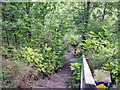
Woolsthorpe: steps on the Skillington footpath
The footpath crosses the trackbed of the High Dyke Branch. The steps lead down what was once an ironstone quarry face (Colsterworth North Quarry). See other photos nearby for more on the quarries and railways of the area.
Image: © John Sutton
Taken: 27 Aug 2009
0.11 miles
7
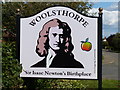
Sign at Woolsthorpe-by-Colsterworth
The sign is located along the lane on the western edge of the hamlet.
Woolsthorpe-by-Colsterworth is a hamlet in the South Kesteven district of Lincolnshire. It is best known as the birthplace of Sir Isaac Newton, at Woolsthorpe Manor. It lies 1km northwest of the larger village of Colsterworth, next to the A1 Great North Road.
Image: © Mat Fascione
Taken: 18 Aug 2019
0.11 miles
8
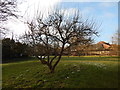
Open space at Woolsthorpe Manor
Behind is Isaac Newton's Tree.
Image: © Hamish Griffin
Taken: 3 Feb 2015
0.11 miles
10
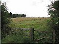
Woolsthorpe: former ironstone quarry
The huge Colsterworth No 2 Extension Quarry extended south-west from here almost as far as Stainby. The stile is the start of a footpath which crosses the restored quarry land, southwards for a few hundred yards, then westwards to the Viking Way near Buckminster. See other photos nearby for more on quarries and quarry railways in the area.
Image: © John Sutton
Taken: 27 Aug 2009
0.12 miles