IMAGES TAKEN NEAR TO
Woodlands Drive, GRANTHAM, NG33 5NH
Introduction
This page details the photographs taken nearby to Woodlands Drive, NG33 5NH by members of the Geograph project.
The Geograph project started in 2005 with the aim of publishing, organising and preserving representative images for every square kilometre of Great Britain, Ireland and the Isle of Man.

There are currently over 7.5m images from over14,400 individuals and you can help contribute to the project by visiting https://www.geograph.org.uk
Image Map
Images are licensed for reuse under creativecommons.org/licenses/by-sa/2.0
Notes
- Clicking on the map will re-center to the selected point.
- The higher the marker number, the further away the image location is from the centre of the postcode.
Image Listing (102 Images Found)
Images are licensed for reuse under creativecommons.org/licenses/by-sa/2.0
Image
Details
Distance
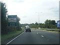
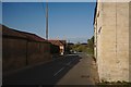
1

Footpath at Colsterworth
This footpath leads from Back Lane through the estate at Colster Way before reaching the A1. It used to continue all the way to Burton-le-Coggles as Colterworth Lane and that is still how it is shown on Ordnance Survey Maps but you would take your life in your hands trying to cross the A1 there now. This is the view from Back Lane with the school on the right.
Image: © Marathon
Taken: 7 Sep 2019
0.12 miles
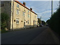
4
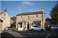
Millstone House
I liked the dolls house in the upper window adding a slightly surreal effect
Image: © Bob Harvey
Taken: 19 Oct 2018
0.16 miles
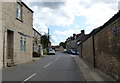
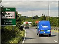
7
North Road
This was once the Great North Road, Stage coaches would have rattled through here and early motor traffic. The "Colsterworth Diverson" along the present route of the A1 dates back to the 1920s, and was dualled in the late 1960s. But this, joining up with the High Dyke a little further north, was the older road.
Image: © Bob Harvey
Taken: 19 Oct 2018
0.17 miles